Local Government
East Fremantle
Region
Metropolitan
7 Aldgate Pl East Fremantle
Including 55b Staton Rd
Aldgate
East Fremantle
Metropolitan
Constructed from 1895
| Type | Status | Date | Documents |
|---|---|---|---|
| Heritage List | Adopted | 17 Nov 2015 | |
| State Register | Registered | 09 May 1997 | HCWebsite.Listing+ListingDocument, HCWebsite.Listing+ListingDocument |
| Type | Status | Date | Documents |
|---|---|---|---|
| (no listings) |
| Type | Status | Date | Grading/Management | |
|---|---|---|---|---|
| Category | ||||
| Municipal Inventory | Adopted | 15 Aug 2006 | Category A | |
| Classified by the National Trust | Classified | 07 May 1979 | ||
| Municipal Inventory | Adopted | 18 Nov 1997 | ||
| Register of the National Estate | Permanent | 28 Sep 1982 | ||
| Library Id | Title | Medium | Year Of Publication |
|---|---|---|---|
| 9943 | Aldgate House, East Fremantle. Ceiling conservation works. | Conservation works report | 2012 |
| 911 | Conservation plan for Aldgate, East Fremantle. | Heritage Study {Cons'n Plan} | 1994 |
| 5387 | Aldgate : conservation plan. | Heritage Study {Cons'n Plan} | 1995 |
Individual Building or Group
| Epoch | General | Specific |
|---|---|---|
| Present Use | RESIDENTIAL | Single storey residence |
| Original Use | RESIDENTIAL | Single storey residence |
| Style |
|---|
| Federation Queen Anne |
| Type | General | Specific |
|---|---|---|
| Wall | BRICK | Common Brick |
| Roof | METAL | Corrugated Iron |
| Wall | STONE | Limestone |
| General | Specific |
|---|---|
| DEMOGRAPHIC SETTLEMENT & MOBILITY | Land allocation & subdivision |
This information is provided voluntarily as a public service. The information provided is made available in good faith and is derived from sources believed to be reliable and accurate. However, the information is provided solely on the basis that readers will be responsible for making their own assessment of the matters discussed herein and are advised to verify all relevant representations, statements and information.
Aesthetic, Historical, Representative & Rarity Aldgate, a substantial single-storey, limestone and brick Federation Queen Anne style residence, has cultural heritage significance for the following reasons: • It is a fine example of the Federation Queen Anne style of architecture common in Perth's suburbs during the 1890s and 1900s; • It is enhanced by its formal approach, the building's close relationship to the paved terrace and orchestrated views west to the harbour and north-west to the Swan River, the place represents the scale and style of residences built on large, river facing lots in East Fremantle during the gold boom period; and • The place has scientific value for the extent and rarity in Western Australia of the original interior decorative treatments and the resource it provides for further study. The five additional houses and associated landscape have low significance. The additions and outbuildings have low significance. AESTHETIC SIGNIFICANCE: Aldgate has exceptional aesthetic value as a fine example of the Federation Queen Anne style. The place is enhanced by hand-painted ceiling murals, friezes and stencils to the interior of the residence. It retains almost all of the characteristic features of a dwelling of the type and period. HISTORIC SIGNIFICANCE: Aldgate has exceptional historic value. It is a reminder of a period when elevated locations on Preston Point Road and the immediate surroundings were desirable residential locations for the more affluent. Aldgate had a close association, for a comparatively short period, with Paul Strelitz. Paul's brother Richard established a trading company and was influential in international trade, diplomacy and local politics in Perth and Fremantle. SCIENTIFIC SIGNIFICANCE: The place has scientific value. The original interior decorative treatments are extensive and rare in Western Australia. The place is a resource that provides for further study. SOCIAL SIGNIFICANCE: Aldgate has exceptional social value. It is associated with a significant area of middle class Federation and Inter-war period development which contributes to the community's sense of place.
Federation Federation Bungalow w Queen Anne Influences No 7 Aldgate Place, Aldgate, is a single storey house constructed in limestone, tuck pointed brick and rendered brick with a hipped and gable corrugated iron roof. Aldgate is a very fine example of the Federation Queen Anne style. The place is enhanced by hand-painted ceiling murals, friezes and stencils to the interior of the residence. The front elevation is asymmetrically planned with a thrust bay and a part width return hip roofed verandah. The verandah is supported on timber posts with a decorative wrought iron frieze. The gable bay features a cartouche and a bay window. The bay window features a pair of double hung sash windows and hopper lights. There is a central door and hopper light flanked by sidelights and double hung sash windows. There is a diagonal corner bay with a pair of windows. A gable sits above the bay. There is a long, elevated approach to the residence. The aesthetic qualities of the place are enhanced with its relationship to the gardens, formal broad stone steps and Italianate balustrades. Although the content of the gardens is of little value. The roofscape features tall render capped chimneys. Walls are tuck pointed brick with rendered quoins. The place retains its form and most of its details. There are additions to the rear and out buildings to the north. The lot has been subdivided and several residences built to the front. These residences and Aldgate share a common road titled Aldgate Place. The place is consistent with the building pattern in the Precinct. The place plays an important role in the pattern of development of a middle class suburb.
Historic Theme: Demographic Settlement In September 1883 Stephen Henry Parker and James Morrison of Perth commenced subdivision of 65 acres of land to the north of Canning Road. The subdivision occurred at Swan Locations 63, 176, 219 and the south western portion of Swan Location 306. The subdivision included Preston Point Road, Alcester Gardens, Wolsely Gardens, Victoria Road, Alexandra Road, Parry Avenue, and Salvado Avenue. The Richmond Precinct was owned by Walter Easton and was named after the town of Richmond where Easton lived in England. In 1901 Easton’s sons subdivided Windsor Estate. New streets to the subdivision of the Windsor Estate were named after various members of the Easton family; Walter, Gill, Stratford and Morgan (later Osborne Road). Initially lot sizes were generous but sold at a slow rate. The initial development of the Richmond Precinct occurred at Canning Highway and Preston Point Road. Substantial residences were developed on these streets giving precedence to the future development of Richmond. The distinct architecture of Canning Highway and Preston Point Road distinguish Richmond from the surrounding area. By 1913 there were approximately 40 residences in the area between Preston Point Road and Alexandra Road. Osborne Road, Windsor Road and Gill Street had several buildings apiece by 1913. By 1931 approximately half the lots were developed. In 1921 Richmond Primary School was developed between Windsor and Osborne Road and several Inter-War residences were developed in the immediate area. In the 1930s the Workers’ Homes’ Board developed a number of weatherboard, asbestos, brick and tiled residences. Inter-War style front porches were preferred over Federation style full width verandahs. Redevelopments have occurred throughout the Richmond Precinct. Large lot sizes have allowed Richmond to be subject to the redevelopment of group and multiple housing. However, significant clusters of heritage dwellings remain throughout. Aldgate is significant as an example of residences built on large river facing lots for the more affluent of East Fremantle's citizens in the 1890s and early 1900s. The place is a reminder of a period when the elevated locations on Preston Point Road. The place and its immediate surroundings were desirable residential locations for the more affluent. Aldgate had a close association, for a comparatively short period, with Paul Strelitz. Paul's brother Richard established a trading company and was influential in international trade, diplomacy and local politics in Perth and Fremantle.
Integrity: Very High
Excellent
This information is provided voluntarily as a public service. The information provided is made available in good faith and is derived from sources believed to be reliable and accurate. However, the information is provided solely on the basis that readers will be responsible for making their own assessment of the matters discussed herein and are advised to verify all relevant representations, statements and information.
A large turn o1 the century house, significant for its architectural character of high gabled roofs and wide surrounding verandahs in the bungalow style, set in expansive grounds overlooking the river. Significant also as an example of the expression at that time in suburban housing of the opulence of the merchants who built the house.
A large residence set in extensive grounds, reduced in size in recent years. The house is built of brick and stone, with CGI roofs, ornate timber work to projecting gables , and cast iron lace decoration to verandah posts. A .curved Italianate terrace, with steps down to the gardens gives prominence to the front of the house. The house is characteristic or large houses in East Fremantle set on high ground with extensive views.
Builtc.1900 The house was originally owned by Mr Paul Strelitz, who with his brother Richard were Merchants and Shipping Agents in Fremantle and Kalgoorlie. Most notably they were agents for the German-Australian Steamship Company, shipping explosives, cement and wire for the expanding mining and rural industries in all parts of Western Australia at that time. They were also agents for the Alfred Nobel Hamburg Explosive Company Ltd, and held agencies and magazines all over the go1dfie1ds. Mr Richard Strelitz was Royal Consul for Denmark.
This information is provided voluntarily as a public service. The information provided is made available in good faith and is derived from sources believed to be reliable and accurate. However, the information is provided solely on the basis that readers will be responsible for making their own assessment of the matters discussed herein and are advised to verify all relevant representations, statements and information.
101 Canning Hwy East Fremantle
REGISTERED AS PART OF 789
East Fremantle
Metropolitan
Constructed from 1900
| Type | Status | Date | Documents |
|---|---|---|---|
| Heritage List | Adopted | 17 Nov 2015 |
| Type | Status | Date | Documents |
|---|---|---|---|
| (no listings) |
| Type | Status | Date | Grading/Management | |
|---|---|---|---|---|
| Category | ||||
| Classified by the National Trust | Recorded | 02 Jul 1979 | ||
| Register of the National Estate | Indicative Place | |||
| Local Heritage Survey | Adopted | 17 Nov 2015 | Category A | |
| Municipal Inventory | Adopted | 18 Nov 1997 | Category A | |
00789 Public Buildings, East Fremantle
| Library Id | Title | Medium | Year Of Publication |
|---|---|---|---|
| 9671 | Post and telegraph office (fmr), East Fremantle: conservation plan. | Heritage Study {Cons'n Plan} | 2010 |
Individual Building or Group
| Epoch | General | Specific |
|---|---|---|
| Present Use | Transport\Communications | Comms: Post or Telegraph Office |
| Original Use | Transport\Communications | Comms: Post or Telegraph Office |
| Style |
|---|
| Federation Free Style |
| Type | General | Specific |
|---|---|---|
| Roof | METAL | Corrugated Iron |
| Wall | STONE | Other Stone |
| General | Specific |
|---|---|
| TRANSPORT & COMMUNICATIONS | Mail services |
This information is provided voluntarily as a public service. The information provided is made available in good faith and is derived from sources believed to be reliable and accurate. However, the information is provided solely on the basis that readers will be responsible for making their own assessment of the matters discussed herein and are advised to verify all relevant representations, statements and information.
Constructed from 1900
Aesthetic, Historical, Social, Representative & Rarity STATEMENT OF SIGNIFICANCE Public Buildings, East Fremantle (1899-1902), comprising a single storey limestone construction and iron roof former Police Station (1899), a two storey rendered brick and Colorbond roof Town Hall (1900), and a two storey brick and rendered brick corrugated iron roofed former Post Office (1901), has cultural heritage significance for the following reasons: The group is significant in the occupation of Western Australia, as the public buildings of the Town of East Fremantle (founded 1897), which was brought about by the rapid expansion of Fremantle following the Western Australian Gold Boom; The group, and in particular the former East Fremantle Post Office in its prominent position at the corner of Canning Highway and King Street, now the junction with Stirling Highway, provides a visual focal point with strong aesthetic value and is a notable landmark; the Town Hall has a fine façade rendered in the Federation Free Classical style; The former Police Station is a competently executed Federation Bungalow style building, which retains much of its original external detail; and the former Post Office is a finely designed two storey Federation Classical style building, with much of its exterior and interior detailing intact; the Town Hall building is one of the more important works of prominent immigrant architect J. F. Allen; and The group has some rarity value as a group of civic places built in a very close timeframe of three years and because the outward appearance of each of the buildings in the group has changed very little. AESTHETIC SIGNIFICANCE East Fremantle Post Office has exceptional aesthetic value as a two storey Post Office in the Federation Free Classical style. The place is located in a prominent position at the corner of Canning Highway and Stirling Highway. It provides a visual focal point with strong aesthetic value and is a notable landmark. HISTORIC SIGNIFICANCE Public Buildings, East Fremantle has exceptional historic value. They are significant in the occupation of Western Australia as the public buildings of the Town of East Fremantle. They were brought about by the rapid expansion of Fremantle following the Western Australian Gold Boom. SCIENTIFIC SIGNIFICANCE N/A SOCIAL SIGNIFICANCE No 101 Canning Highway has exceptional social value. It is associated with development and expansion of East Fremantle.
A large face brick house with upper surfaces of pebble and dash stucco, symmetrical street elevation with projecting central gabled bay. Arts and Craft influence in the mitred hipped slate roof, elevations and chimney design. No 101 Canning Highway is part of Public Buildings, East Fremantle. The Public Buildings, East Fremantle provides a visual focal point for the Town with strong aesthetic value. The former East Fremantle Post Office is located in a prominent position at the corner of Canning Highway and Stirling Highway (formerly King Street). The group exhibits the aesthetic characteristics of a small significant group of public buildings constructed in the Federation Free Classical and Federation Bungalow styles. The group was built between 1899-1902. The Town Hall has a fine façade rendered in the Federation Free Classical Style. The former Police Station is a competently executed Federation Bungalow. The place retains much of its original external detail. The former Post Office is a finely designed two storey Federation Classical style building. Most of its exterior and interior detailing are still intact. It is constructed in brick and rendered brick with a corrugated iron roof. There is a brick construction former mailroom to the rear, which also accommodated amenities and cycle storage. The building is the westernmost of the group of places. The front elevation is symmetrically planned with an ABBA rhythm. The lower floor is a rendered rusticated storey with single pane double hung sash windows. Each of the windows has modern security grilles fixed over the outside face. The end bays contain symmetrically disposed porches with arched openings. The first floor openings are double hung sash windows. The porches feature original four pane timber doors with hopper lights. The floor is replacement granolithic. The windows over the porch are a later infill. The east and west elevations reflect the front elevation. The rear elevation features a two storey verandah that has been mostly enclosed. The roofscape features a stout rendered chimney. Individually the buildings exhibit pleasing aesthetic qualities. Public Buildings, East Fremantle has a landmark quality in Canning Highway and at the junction with Stirling Highway. The landmark quality has been enhanced by virtue of the construction of Stirling Bridge and the extension of Stirling Highway. The extension has opened up a previously unintended vista giving the group a high degree of visual prominence. Public Buildings, East Fremantle together forms a significant and notable streetscape. They have formed a cultural environment through their service as the public buildings of the Town of East Fremantle throughout most of the twentieth century. The group represents the historic civic heart of East Fremantle and the effect of the group reflects these civic qualities. CONSTRUCTION MATERIALS Walls – Brick and rendered brick Roof – Iron PHYSICAL SETTING The place is located on the pavement edge of Canning Highway.
Historic Theme: Transport & Communications Public Buildings, East Fremantle is significant in the occupation of Western Australia. The public buildings of the Town of East Fremantle mark the creation of the Town of East Fremantle in 1897 brought about by the rapid expansion of Fremantle. Public Buildings, East Fremantle were constructed in 1899-1902. The construction followed the proclamation of the Town of East Fremantle and in the period immediately following the Western Australian Gold Boom. The group is the product of a rapid period of expansion and development with the whole group being completed by 1902. Well-known Architect Joseph F. Allen designed both the initial stages of East Fremantle Town Hall, including the Mechanics’ Institute and Library. Allen later became Mayor of East Fremantle. The first Town Clerk of East Fremantle, Horace Hill Parker, worked at the place for more than 40 years, and resided there in the early period following its completion. Hillson Beasley designed the Police Station and it is likely that he was responsible for the design of the Post Office. On 14 March 1898, the Plympton Post Office opened in makeshift premises with Miss J. Adams as Postmistress. In 1899, the Plympton Post Office was renamed East Fremantle Post Office. On 7 July 1981, the former Post Office and quarters were transferred to the Commissioner of Main Roads. HISTORIC THEME Transport and Communications - Postal Services
Integrity: Very High
Excellent
This information is provided voluntarily as a public service. The information provided is made available in good faith and is derived from sources believed to be reliable and accurate. However, the information is provided solely on the basis that readers will be responsible for making their own assessment of the matters discussed herein and are advised to verify all relevant representations, statements and information.
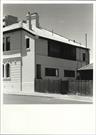
133 Canning Hwy East Fremantle
East Fremantle
Metropolitan
| Type | Status | Date | Documents |
|---|---|---|---|
| Heritage List | Adopted | 17 Nov 2015 |
| Type | Status | Date | Documents |
|---|---|---|---|
| (no listings) |
| Type | Status | Date | Grading/Management | |
|---|---|---|---|---|
| Category | ||||
| Municipal Inventory | Adopted | 18 Nov 1997 | Category A | |
| Local Heritage Survey | Adopted | 17 Nov 2015 | Category A | |
00789 Public Buildings, East Fremantle
Individual Building or Group
| Epoch | General | Specific |
|---|---|---|
| Original Use | GOVERNMENTAL | Police Station or Quarters |
| Style |
|---|
| Victorian Georgian |
| Type | General | Specific |
|---|---|---|
| Roof | METAL | Corrugated Iron |
| Wall | STONE | Other Stone |
| General | Specific |
|---|---|
| SOCIAL & CIVIC ACTIVITIES | Law & order |
This information is provided voluntarily as a public service. The information provided is made available in good faith and is derived from sources believed to be reliable and accurate. However, the information is provided solely on the basis that readers will be responsible for making their own assessment of the matters discussed herein and are advised to verify all relevant representations, statements and information.
Aesthetic, Historical, Social, Representative & Rarity STATEMENT OF SIGNIFICANCE Public Buildings, East Fremantle (1899-1902), comprising a single storey limestone construction and iron roof former Police Station (1899), a two storey rendered brick and Colorbond roof Town Hall (1900), and a two storey brick and rendered brick corrugated iron roofed former Post Office (1901), has cultural heritage significance for the following reasons: The group is significant in the occupation of Western Australia, as the public buildings of the Town of East Fremantle (founded 1897), which was brought about by the rapid expansion of Fremantle following the Western Australian Gold Boom; The group, and in particular the former East Fremantle Post Office in its prominent position at the corner of Canning Highway and King Street, now the junction with Stirling Highway, provides a visual focal point with strong aesthetic value and is a notable landmark; the Town Hall has a fine façade rendered in the Federation Free Classical style; The former Police Station is a competently executed Federation Bungalow style building, which retains much of its original external detail; and the former Post Office is a finely designed two- storey Federation Classical style building, with much of its exterior and interior detailing intact; the Town Hall building is one of the more important works of prominent immigrant architect J. F. Allen; and The group has some rarity value as a group of civic places built in a very close timeframe of three years and because the outward appearance of each of the buildings in the group has changed very little. AESTHETIC SIGNIFICANCE The former Police Station has exceptional aesthetic value as a competently executed Federation Bungalow style building. The place retains much of its original external detail. HISTORIC SIGNIFICANCE Public Buildings, East Fremantle has exceptional historic value. They are significant in the occupation of Western Australia as the public buildings of the Town of East Fremantle. They were brought about by the rapid expansion of Fremantle following the Western Australian Gold Boom. SCIENTIFIC SIGNIFICANCE N/A SOCIAL SIGNIFICANCE No 133 Canning Highway has exceptional social value. It is associated with development and expansion of East Fremantle.
Federation Federation Rustic w Georgian Influences No 133 Canning Highway is part of Public Buildings, East Fremantle. The Public Buildings, East Fremantle provides a visual focal point for the Town with strong aesthetic value. The former East Fremantle Post Office is located in a prominent position at the corner of Canning Highway and Stirling Highway (formerly King Street). The group exhibits the aesthetic characteristics of a small significant group of public buildings constructed in the Federation Free Classical and Federation Bungalow styles. The group was built between1899-1902. The Town Hall has a fine façade rendered in the Federation Free Classical Style. The former Police Station is a competently executed Federation Bungalow. The place retains much of its original external detail. The place is a single storey building constructed in limestone and brick with a hipped corrugated iron roof. The place features a police station and quarters, charge room, cell yard, two brick cells and a timber laundry. The building is located to the east of the former Post Office. The front elevation is asymmetrically planned with a full width return hip roofed verandah. The verandah is supported on timber posts with post brackets. The return section of the verandah is a later addition. There is a central door flanked by double hung sash windows. The roofscape features a pair of tall brick chimneys. The former Post Office is a finely designed two storey Federation Classical style building. Most of its exterior and interior detailing are still intact. Individually the buildings exhibit pleasing aesthetic qualities. Public Buildings, East Fremantle has a landmark quality in Canning Highway and at the junction with Stirling Highway. The landmark quality has been enhanced by virtue of the construction of Stirling Bridge and the extension of Stirling Highway. The extension has opened up a previously unintended vista giving the group a high degree of visual prominence. Public Buildings, East Fremantle together forms a significant and notable streetscape. They have formed a cultural environment through their service as the public buildings of the Town of East Fremantle throughout most of the twentieth century. The group represents the historic civic heart of East Fremantle and the effect of the group reflects these civic qualities. CONSTRUCTION MATERIALS Walls – Limestone and brick Roof – Corrugated iron sheeting PHYSICAL SETTING The place is located on a sloping site with a small garden. There is a timber picket fence on the front lot boundary.
Historic Theme: Demographic Settlement Historic Theme: Spcial & Civic Activities Public Buildings, East Fremantle is significant in the occupation of Western Australia. The public buildings of the Town of East Fremantle mark the creation of the Town of East Fremantle in 1897 brought about by the rapid expansion of Fremantle. Public Buildings, East Fremantle were constructed in 1899-1902. The construction followed the proclamation of the Town of East Fremantle and in the period immediately following the Western Australian Gold Boom. The group is the product of a rapid period of expansion and development with the whole group being completed by 1902. Well-known Architect Joseph F. Allen designed both the initial stages of East Fremantle Town Hall, including the Mechanics’ Institute and Library. Allen later became Mayor of East Fremantle. The first Town Clerk of East Fremantle, Horace Hill Parker, worked at the place for more than 40 years, and resided there in the early period following its completion. Hillson Beasley designed the Police Station and it is likely that he was responsible for the design of the Post Office. On 31 December 1898, Plympton Police Station commenced operation under P.C. Leary in rented premises in Glyde Street, East Fremantle. The premises belonged to Mrs Maryanne Waterhouse. The place was used as a Police Station until 27 September 1899. In 1899 the East Fremantle Police Station was constructed by W. Sharp in its current location. HISTORIC THEME Demographic Settlements - Residential Subdivision
Integrity: Very High
Good
This information is provided voluntarily as a public service. The information provided is made available in good faith and is derived from sources believed to be reliable and accurate. However, the information is provided solely on the basis that readers will be responsible for making their own assessment of the matters discussed herein and are advised to verify all relevant representations, statements and information.
133,135 &101 Canning Hwy East Fremantle
Includes: Police Station, Town Hall; Mechanics’ Institute and Library and Post office Group (1899, 1900 and 1902, and 1901); State Emergency Headquarters.
East Fremantle Post Office, Police Stn, Town
Mechanics Inst & Library & PO Group SES Hdqtr
East Fremantle
Metropolitan
Constructed from 1899 to 1902
| Type | Status | Date | Documents |
|---|---|---|---|
| Heritage Agreement | YES | 16 Mar 2020 | HCWebsite.Listing+ListingDocument |
| Heritage List | Adopted | 17 Nov 2015 | |
| State Register | Registered | 23 Jun 2000 | HCWebsite.Listing+ListingDocument, HCWebsite.Listing+ListingDocument |
| Type | Status | Date | Documents |
|---|---|---|---|
| (no listings) |
| Type | Status | Date | Grading/Management | |
|---|---|---|---|---|
| Category | ||||
| Register of the National Estate | Indicative Place | |||
| Classified by the National Trust | Recorded | 02 Jul 1979 | ||
| Local Heritage Survey | Adopted | 17 Nov 2015 | Category A | |
| Name | Type | Year From | Year To |
|---|---|---|---|
| Charles Oldham, Boas Ednie Brown & Partners | Architect | - | - |
| Joseph Francis Allen | Architect | - | - |
| Hillson Beasley | Architect | - | - |
| Library Id | Title | Medium | Year Of Publication |
|---|---|---|---|
| 9671 | Post and telegraph office (fmr), East Fremantle: conservation plan. | Heritage Study {Cons'n Plan} | 2010 |
| 9999 | East Fremantle Town Hall, Structural report. | Heritage Study {Other} | 2010 |
| 10009 | East Fremantle Town Hall Complex. | Heritage Study {Cons'n Plan} | 2004 |
| 5813 | Former East Fremantle Post Office, 101 Canning Highway, East Fremantle : maintenance works 2002. | Report | 2002 |
Individual Building or Group
| Epoch | General | Specific |
|---|---|---|
| Present Use | COMMERCIAL | Other |
| Original Use | Transport\Communications | Comms: Post or Telegraph Office |
| Present Use | COMMERCIAL | Shop\Retail Store {single} |
| Present Use | GOVERNMENTAL | Town, Shire or District Hall |
| Original Use | GOVERNMENTAL | Police Station or Quarters |
| Original Use | GOVERNMENTAL | Town, Shire or District Hall |
| Style |
|---|
| Federation Free Classical |
| Federation Bungalow |
| Victorian Georgian |
| Type | General | Specific |
|---|---|---|
| Wall | BRICK | Rendered Brick |
| Roof | METAL | Corrugated Iron |
| Wall | STONE | Limestone |
| Roof | ASBESTOS | Fibrous Cement, corrugated |
| General | Specific |
|---|---|
| SOCIAL & CIVIC ACTIVITIES | Government & politics |
| TRANSPORT & COMMUNICATIONS | Mail services |
| SOCIAL & CIVIC ACTIVITIES | Community services & utilities |
| SOCIAL & CIVIC ACTIVITIES | Law & order |
This information is provided voluntarily as a public service. The information provided is made available in good faith and is derived from sources believed to be reliable and accurate. However, the information is provided solely on the basis that readers will be responsible for making their own assessment of the matters discussed herein and are advised to verify all relevant representations, statements and information.
This information is provided voluntarily as a public service. The information provided is made available in good faith and is derived from sources believed to be reliable and accurate. However, the information is provided solely on the basis that readers will be responsible for making their own assessment of the matters discussed herein and are advised to verify all relevant representations, statements and information.
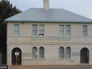
135 Canning Hwy East Fremantle
East Fremantle
Metropolitan
Constructed from 1920 to 1930
| Type | Status | Date | Documents |
|---|---|---|---|
| Heritage List | Adopted | 17 Nov 2015 |
| Type | Status | Date | Documents |
|---|---|---|---|
| (no listings) |
| Type | Status | Date | Grading/Management | |
|---|---|---|---|---|
| Category | ||||
| Local Heritage Survey | Adopted | 17 Nov 2015 | Category A | |
| Statewide War Memorial Survey | Completed | 01 May 1996 | ||
00789 Public Buildings, East Fremantle
Historic site
| Epoch | General | Specific |
|---|---|---|
| Present Use | MONUMENT\CEMETERY | Monument |
| Original Use | MONUMENT\CEMETERY | Monument |
| Type | General | Specific |
|---|---|---|
| Other | STONE | Marble |
This information is provided voluntarily as a public service. The information provided is made available in good faith and is derived from sources believed to be reliable and accurate. However, the information is provided solely on the basis that readers will be responsible for making their own assessment of the matters discussed herein and are advised to verify all relevant representations, statements and information.
This information is provided voluntarily as a public service. The information provided is made available in good faith and is derived from sources believed to be reliable and accurate. However, the information is provided solely on the basis that readers will be responsible for making their own assessment of the matters discussed herein and are advised to verify all relevant representations, statements and information.
135 Canning Hwy East Fremantle
REGISTERED AS PART OF 789
East Fremantle
Metropolitan
Constructed from 1899
| Type | Status | Date | Documents |
|---|---|---|---|
| Heritage List | Adopted | 17 Nov 2015 |
| Type | Status | Date | Documents |
|---|---|---|---|
| (no listings) |
| Type | Status | Date | Grading/Management | |
|---|---|---|---|---|
| Category | ||||
| Local Heritage Survey | Adopted | 17 Nov 2015 | Category A | |
| Municipal Inventory | Adopted | 18 Nov 1997 | Category A | |
| Classified by the National Trust | Recorded | 02 Jul 1979 | ||
00789 Public Buildings, East Fremantle
| Name | Type | Year From | Year To |
|---|---|---|---|
| Joseph Francis Allen | Architect | - | - |
| Library Id | Title | Medium | Year Of Publication |
|---|---|---|---|
| 407 | East Fremantle town hall: colour. | Heritage Study {Other} | 1994 |
| 10009 | East Fremantle Town Hall Complex. | Heritage Study {Cons'n Plan} | 2004 |
Individual Building or Group
| Epoch | General | Specific |
|---|---|---|
| Original Use | GOVERNMENTAL | Town, Shire or District Hall |
| Present Use | GOVERNMENTAL | Town, Shire or District Hall |
| Style |
|---|
| Federation Free Classical |
| General | Specific |
|---|---|
| SOCIAL & CIVIC ACTIVITIES | Government & politics |
This information is provided voluntarily as a public service. The information provided is made available in good faith and is derived from sources believed to be reliable and accurate. However, the information is provided solely on the basis that readers will be responsible for making their own assessment of the matters discussed herein and are advised to verify all relevant representations, statements and information.
Constructed from 1899
Aesthetic, Historical, Social, Representative & Rarity STATEMENT OF SIGNIFICANCE Public Buildings, East Fremantle (1899-1902), comprising a single storey limestone construction and iron roof former Police Station (1899), a two storey rendered brick and Colorbond roof Town Hall (1900), and a two storey brick and rendered brick corrugated iron roofed former Post Office (1901), has cultural heritage significance for the following reasons: The group is significant in the occupation of Western Australia, as the public buildings of the Town of East Fremantle (founded 1897), which was brought about by the rapid expansion of Fremantle following the Western Australian Gold Boom; The group, and in particular the former East Fremantle Post Office in its prominent position at the corner of Canning Highway and King Street, now the junction with Stirling Highway, provides a visual focal point with strong aesthetic value and is a notable landmark; the Town Hall has a fine façade rendered in the Federation Free Classical style; The former Police Station is a competently executed Federation Bungalow style building, which retains much of its original external detail; and the former Post Office is a finely designed two storey Federation Classical style building, with much of its exterior and interior detailing intact; the Town Hall building is one of the more important works of prominent immigrant architect J. F. Allen; and The group has some rarity value as a group of civic places built in a very close timeframe of three years and because the outward appearance of each of the buildings in the group has changed very little. AESTHETIC SIGNIFICANCE East Fremantle Town Hall has exceptional aesthetic value as a very fine expression of the Federation Free Classical style. The place is located in a prominent position on Canning Highway. It provides a visual focal point with strong aesthetic value and is a notable landmark. HISTORIC SIGNIFICANCE Public Buildings, East Fremantle has exceptional historic value. They are significant in the occupation of Western Australia as the public buildings of the Town of East Fremantle. They were brought about by the rapid expansion of Fremantle following the Western Australian Gold Boom. SCIENTIFIC SIGNIFICANCE N/A SOCIAL SIGNIFICANCE No 135 Canning Highway has exceptional social value. It is associated with development and expansion of East Fremantle.
No 135 Canning Highway is part of Public Buildings, East Fremantle. The Public Buildings, East Fremantle provides a visual focal point for the Town with strong aesthetic value. The former East Fremantle Post Office is located in a prominent position at the corner of Canning Highway and Stirling Highway (formerly King Street). The group exhibits the aesthetic characteristics of a small significant group of public buildings constructed in the Federation Free Classical and Federation Bungalow styles. The group was built between 1899-1902. The Town Hall has a fine façade rendered in the Federation Free Classical Style. The place is a two storey building constructed in limestone and rendered brick with a hipped corrugated iron roof. The building is located east of the former Police Station. Most of the site has been bitumised to accommodate parking. There is a car park to the rear and west of the building. The place sits on limestone foundations. Walls are rendered and have been repainted in the early 21st Century. The front elevation is symmetrically planned with an ABABA rhythm of major and minor bays. The ground floor elevation features arched head timber panelled doors. The doors are flanked by pairs of low arched head windows set over a rendered plinth. The opening pattern is reflected on the first floor. The first floor windows are double hung sashes with a semi-circular head with a keystone and moulded arches. Above the first floor is a deep entablature supported on console brackets. The detail runs across the whole facade. The two major bays mark the original entry points to the building. The eastern entry remains in use. A steel fire escape stair has been constructed on the west elevation. There are additions to the rear and side of the place. The former Police Station is a competently executed Federation Bungalow. The place retains much of its original external detail. The former Post Office is a finely designed two storey Federation Classical style building. Most of its exterior and interior detailing are still intact. Individually the buildings exhibit pleasing aesthetic qualities. Public Buildings, East Fremantle has a landmark quality in Canning Highway and at the junction with Stirling Highway. The landmark quality has been enhanced by virtue of the construction of Stirling Bridge and the extension of Stirling Highway. The extension has opened up a previously unintended vista giving the group a high degree of visual prominence. Public Buildings, East Fremantle together forms a significant and notable streetscape. They have formed a cultural environment through their service as the public buildings of the Town of East Fremantle throughout most of the twentieth century. The group represents the historic civic heart of East Fremantle and the effect of the group reflects these civic qualities. CONSTRUCTION MATERIALS Walls – Limestone and rendered brick Roof – Corrugated iron sheeting PHYSICAL SETTING The place is located on a sloping lot built to two lot boundaries.
Historic Theme: Community Efforts Public Buildings, East Fremantle is significant in the occupation of Western Australia. The public buildings of the Town of East Fremantle mark the creation of the Town of East Fremantle in 1897 brought about by the rapid expansion of Fremantle. Public Buildings, East Fremantle were constructed in 1899-1902. The construction followed the proclamation of the Town of East Fremantle and in the period immediately following the Western Australian Gold Boom. The group is the product of a rapid period of expansion and development with the whole group being completed by 1902. Well-known Architect Joseph F. Allen designed both the initial stages of East Fremantle Town Hall, including the Mechanics’ Institute and Library. Allen later became Mayor of East Fremantle. The first Town Clerk of East Fremantle, Horace Hill Parker, worked at the place for more than 40 years, and resided there in the early period following its completion. Hillson Beasley designed the Police Station and it is likely that he was responsible for the design of the Post Office. East Fremantle Town Hall was designed by Architect Joseph F Allen. The Town Hall was constructed in 1899-1900. The building included offices, town hall and quarters for the Town Clerk, who took up residence at the place on its completion. In 1902 additions were made to the east side and rear of the Town Hall. The additions were designed by Joseph F Allen and included accommodation for the Library and Mechanics Institute. HISTORIC THEME Community Efforts - Local Government
Integrity: High
Good
This information is provided voluntarily as a public service. The information provided is made available in good faith and is derived from sources believed to be reliable and accurate. However, the information is provided solely on the basis that readers will be responsible for making their own assessment of the matters discussed herein and are advised to verify all relevant representations, statements and information.
208 Canning Hwy East Fremantle
East Fremantle
Metropolitan
| Type | Status | Date | Documents |
|---|---|---|---|
| (no listings) |
| Type | Status | Date | Documents |
|---|---|---|---|
| (no listings) |
| Type | Status | Date | Grading/Management | |
|---|---|---|---|---|
| Category | ||||
| (no listings) | ||||
00805 Woodlawn
Tree
| Epoch | General | Specific |
|---|---|---|
| Present Use | OTHER | Other |
| Original Use | OTHER | Other |
This information is provided voluntarily as a public service. The information provided is made available in good faith and is derived from sources believed to be reliable and accurate. However, the information is provided solely on the basis that readers will be responsible for making their own assessment of the matters discussed herein and are advised to verify all relevant representations, statements and information.
18 Dalgety St East Fremantle
Moore Family Residence
Woodside
East Fremantle
Metropolitan
Constructed from 1897 to 1904
| Type | Status | Date | Documents |
|---|---|---|---|
| Heritage Agreement | YES | 28 Aug 2017 | HCWebsite.Listing+ListingDocument |
| Heritage List | Adopted | 17 Nov 2015 | |
| State Register | Registered | 06 Feb 1998 | HCWebsite.Listing+ListingDocument, HCWebsite.Listing+ListingDocument |
| Type | Status | Date | Documents |
|---|---|---|---|
| (no listings) |
| Type | Status | Date | Grading/Management | |
|---|---|---|---|---|
| Category | ||||
| Register of the National Estate | Indicative Place | |||
| Classified by the National Trust | Recorded | 04 Jun 1979 | ||
| Classified by the National Trust | Classified | 14 Apr 1998 | ||
| Municipal Inventory | Adopted | 18 Nov 1997 | Category A | |
| Name | Type | Year From | Year To |
|---|---|---|---|
| Frederick William Burwell | Architect | - | - |
| O. N. Nicholson | Architect | - | - |
| Library Id | Title | Medium | Year Of Publication |
|---|---|---|---|
| 12001 | Woodside Hospital Interpretation Strategy | Heritage Study {Other} | 2020 |
| 11483 | Medical background: Being a history of Fremantle hospitals and doctors | Book | 1969 |
| 9081 | Woodside Hospital (fmr). Conservation plan. | Heritage Study {Cons'n Plan} | 2008 |
Individual Building or Group
| Epoch | General | Specific |
|---|---|---|
| Original Use | RESIDENTIAL | Two storey residence |
| Present Use | HEALTH | Hospital |
| Style |
|---|
| Federation Free Classical |
| Type | General | Specific |
|---|---|---|
| Wall | BRICK | Rendered Brick |
| Wall | BRICK | Common Brick |
| General | Specific |
|---|---|
| DEMOGRAPHIC SETTLEMENT & MOBILITY | Settlements |
| SOCIAL & CIVIC ACTIVITIES | Community services & utilities |
| OCCUPATIONS | Commercial & service industries |
This information is provided voluntarily as a public service. The information provided is made available in good faith and is derived from sources believed to be reliable and accurate. However, the information is provided solely on the basis that readers will be responsible for making their own assessment of the matters discussed herein and are advised to verify all relevant representations, statements and information.
Woodside Hospital, originally an imposing Federation Free Classical style single and two-storey brick and rendered town house, now converted into a maternity hospital, has cultural heritage significance for the following reasons: • the place is important as a leading maternity hospital serving the Fremantle and District community; • the place is important for its associations, as a rural holding and home near the commercial centre of nearby Fremantle; • Moore's estate was subdivided to fonn a sizeable portion of the municipality of East Fremantle and the street names have associations with the Moore family; • the location, distinctive size, design and presence of the place is highly valued by the community as a prominent former residence in the East Fremantle municipality; • the building has well crafted, high quality components assembled in a conservative manner; and, • the place, as the main Moore family residence, is important for its association with the Moore family in general, and W.D. Moore in particular. Moore is well known as the founder of the retailers, W.D Moore and Co, and its later derivations, Dalgety's and Moore's, for his business associations in banking and insurance, and his political, pastoral and rural accomplishments in Fremantle, the North West and throughout the State. Aesthetic Value Woodside Hospital is a collation of well designed and made, good quality and expensive components assembled in a conservative manner. Woodside Hospital is valued by the community as a minor landmark. Historic Value The hospital was established to meet the demands of the local community and has been a leader in the evolution of modern maternity practice in Western Australia, including the introduction of home-birthing and postnatal support services. As the former main Moore family residence, Woodside Hospital is significant due to its association with the Moore family in general, and W.D. Moore in particular. Moore is well known as the founder of the retailer, WD. Moore & Co, and its later derivations, Dalgety 's, and Moore's, for his business associations in banking and insurance, and his political, pastoral and rural accomplishments in Fremantle, the North-West and throughout the State. Scientific Value Woodside Hospital may have scientific value for the study of the evolution of modem maternity care since the 1950s. Social Value Woodside Hospital is important for its associations with the community as a leading maternity hospital, serving the Fremantle and District community. Woodside Hospital is highly valued by the community as a health-service provider. Woodside Hospital is important for its associations primarily as a rural holding and home near the business base in nearby Fremantle and with the origins of the East Fremantle municipality, including the street layout. The place and its functions provide a significant contribution to the sense of place of the community. Rarity Woodside Hospital is of exceptional interest as the residence of a successful businessman, pioneer of the pastoral industry and politician. The building marked W.D. Moore's rural holding known for its prom inently located vines and orchard. Representativeness The location and design of Woodside Hospital as a residence demonstrates the way of life of a late nineteenth century businessman and his family in a self contained rural setting. It is also a demonstration of the philosophy of the family patriarch in building what was perceived at the time as a sustainable base for the preservation of the wealth and lifestyle of his descendants. Woodside Hospital is representative of the philosophy of maternity care in Western Australian health. Condition Overall, the condition of the original structure including the original eastern extension (but not the north-south wing) is good. Integrity Woodside Hospital retains a moderate degree of integrity. It is no longer used as a family residence , although its use as a general hospital since 1924 and a maternity hospital since 1953 does reflect the original intention of a family-based place. Authenticity The building retains a high degree of authenticity. In converting the building to the exacting requirements of a modem maternity hospital, it is to be expected that the interior will be modified. Fortunately, alterations to the main building and single-storey eastern extension have been generally limited to minor layout changes and the installation and later modification of wet areas. Woodside Hospital has been painted externally and consequently the intent of the designer, in terms of the emphasis, detail and rhythm of the original materials, has been lost. The ground floor plinths, the first floor level slab edge, the cast iron balustrade, the guttering and the pediment have been picked out in dark brown paint, further confusing the lines of the building,. The finejoinery, the cast iron balustrade and rendered modelling are intact and some fabric of the tiling at the entry remains. Woodwork and joinery has been painted in light colours and much of the hardware and fittings have required replacement due to the heavy usage not expected in a residential setting. The staircase, glass, interior plaste1work and fireplaces remain, or sufficient fabric remains, to provide a pattern should future restoration and conservation be contemplated .
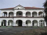
The current site of Woodside Hospi tal is about one hectare, with frontage to Dalgety Street on the west and Fortescue Street on the east. The two-storey portion of the residence is in the centre of the square holding, with l,OOOsqm residential blocks to the north and south, and opposite in the fronting streets. The building is about 200 metres from the Canning Highway alignment, the intervening residences screening Woodside Hospital visually from that position. As the imposing building faces north, it was no doubt intended to address Canning Road. Some important trees remain in the grounds including mature olives, most likely to have originated from Moore's plantings. The original building included the two-storey structure and the extension to the east with the present north-south wing along the eastern side added much later. This later wing presently contains the majority of the nursing facilities, the administration and staff facilities being confined to the western end of the original building. Another later addition is evident along the southern edge of the west block, with its upper level accessed from the upper floor of the balustraded arcade, but approached down a short flight of steps. The present approach to the building is from the west - an elevation almost certainly never intended as the main approach. The rendered modelling of the brick facade remains intact, with cast iron balustrading on the upper floor and granolithic topped concrete verandahs on both levels. Some of the cast iron is marked 'Bloggs and Bloggs'. The entire masonry surface of the original structures has been painted off-white, including the extensive tuck-pointed brickwork. The timber framed joinery is generally intact, with arch headed double hung windows most still with sills just above floor level. The entrance step is paved with encaustic tessera, although some have been replaced. The entrance door is arch headed and contains coloured leadlight glazing. Internally, a short passage leads to a full two-storey height gallery containing a clear finished timber stair said to be imported from England. The upper level south lit gallery has a short return of precast balustrade mark ing an arched arcade leading to the rooms of the west front. A large arch leads to the living rooms along the northern front, and the timber stair balustrade lines a return landing to rooms along the eastern front of the upper floor. Fireplaces, cornices, plaster detail, ventilators, skirtings, architraves, joinery remain, or sufficient fabric remains to provide a clear indication of the sophistication of the finishes incorporated into the structure. On the ground floor, an arch headed opening heralds the passage through the east extension, which ultimately leads to the nursing accommodation wing along the east front which has not been included in the present assessment. Plans for the original structure were not located preventing further interpretation of the original usage of the rooms. The predominant theme of the two-storey section of Woodside Hospital is fanned by the visually substantial brick verandahs with prominent flattened arches on both levels along the north front, returned along the east and west front for several bays. The rendered detail is typical of the Federation Free Classical style for the period in Western Australia. The building is among the most imposing large residences built at the time in Western Australia, the style being more common on civic buildings.
Assessment 1998 Construction 1897, Alterations/Additions 1904, 1966 Architect 1896: O N Nicholson; 1904: F W Burwell Builder 1904: F W Box Woodside Hospital, a two-storey brick building with a brick single-storey wing to the east, was constructed in 1896-97 as a private residence for William Dalgety Moore. The residence was extended in 1904. A single-storey brick addition to the east wing was built in 1966, and today this contains the bulk of the hospital 's nursing facilities. The administrative and staffing facilities are located in the western end of the original build ing . On the approximately one hectare site are also a gardener's shed and a single-storey brick laundry building, , probably built in the 1920s. Mature trees and well cultivated gardens surrnund the buildings. At the left of the main driveway entrance is an expanse of levelled grass adjacent to a group of olive trees. William Dalgety Moore was born in 1835 at Oakover in the Swan Valley into one of the most well regarded families in the colony. His father Samuel, was a respected landowner and successful businessman in Fremantle. However, when Samuel died in 1849 his financial circumstances were poor and his Fremantle business was wound up. The following year young William began working in the Surveyor General's Office. He left four years later to work in the Irwin River district, where he worked on stations and also participated in long exploration trips. Moore returned to Perth in 1862 and started at merchant business in Henry Street, Fremantle. Aside from this enterprise, he also had interests in timber businesses in the south-west, pearling concerns and two general stores in the north, as well as the Phoenix Flour Mill and the Osborne Hotel in Claremont. Moore served for three years as an elected member of the Legislative Council (J 870-73) and returned as a nominee member in 1890 in the new Responsible Government. In the meantime, he was elected as the first chairman of the Fremantle Chamber of Commerce ( 1885).1 He also held positions on the local board of directors of the AMP Society, on the board of advice of Dalgety and Co. and was a director of the Western Australian Bank. In June 1878, Moore began to purchase land in what is now East Fremantle and his holdings became known as the 'Woodside Estate'.2 By March 1885, his estate stretched south to Marmion Street, north to Fremantle road (Canning Highway), east to Petra Street and west to the lot boundary , west of Allen Street.3 In total, Moore's property comprised approximately 55 hectares. Possibly in an attempt to recapture his rural childhood, Moore planted the land extensively with vines as his father had one at Oakover. In addition, there was also orchards, a farmyard, gardens, stables, cottages and pigsties. 4 Moore must have spent a considerable amount on the property , for in 1890 he wrote to his wife complaining that 'Woodside was crippling . him financially and making him ill with worry' .5 However, circumstances must have improved by 1896 as architect O.N. Nicholson called tenders for 'erecting the first section of a large brick and stone two storey residence for W.D. Moore, at his garden Woodside'.6 This section of the building was completed the following year when Moore and his family moved into Woodside, and it is interesting to note that Moore called himself a vigneron for his personal listing in the Postal Directory of that year.7 The ballroom and cloak rooms were added in 1904 by builder F.W. Box, to plans drawn up by architect F.W. Burwell.8 Prior to the move, the family had lived in Cliff Street, Fremantle. It is popularly stated that Moore's eighteen children were born at Woodside, creating a link between its current use as a maternity hospital. However, this myth has no basis in fact as Moore' s first wife, Susanna, died in 1876 after mothering twelve children, and his second wife, Annie, bore six children in the decade following their marriage in 1879.9 Family life at Woodside would therefore have revolved around the entertainment of a large family of young adults. W.D. Moore died at Woodside in 1910, after several years of ill health.IO Annie remained there until 1923 although she did not pass away until the 1940s. The property remained in the Moore family until 1926, although much of the large estate had been subdivided and sold from 1912.11 The streets in the subdivision were named after. Moore family associations and the sale of blocks continued until the 1930s. A flyer for the sale of these properties was fulsome in its praise of the estate: Buy a home-site in this estate which is situated only I Y, miles from Fremantle Railway Station, wharf and Town Hall, whose prolific soil is producing luscious fruits succulent vegetables , splendid lawns and glorious flower, shrubs and trees and whose bracing air can give you and yours health and happiness - business cares and worries left in townn In 1924, the property was used as a hospital for the first time, under the direction of Rose Carlton and the name Woodside Hospital was applied in the l 925 listing of the Post Office Directories. Doctor Edwin Charles East purchased the block containing Woodside Hospital in December 1926, the same year that siblings and nursing sisters Florence and Irene Kiernan took over the management of the place. It is not known whether they leased the prem ises from Dr East or were employed by him to run the hospital. The sisters continued to run the hospital until 1942, when one of them left, and two years later Sister Leggate joined the remaining Kiernan sister asjoint manager of the hospital. The type of service offered during these years is not recorded but it is assumed that it was a general hospitaJ.13 The hospital ceased operating in 1945 or 1946 and the building was modified into a group of six or seven flats.14 The land on which Woodside Hospital stands was further subdivided (to its present size) and in 1948, miner Bertolo Miorada purchased the block. The property changed hands again the following year when it was bought by the Crippled Children's Seaside Home Society. Several sources state that the property proved unsatisfactory for the purposes of this group, but the reason s for this claim are unstated.15 The society retained ownership of the property until 1951 when it was purchased by the state government for £17,000.16 The function of the building during these years (1949- 1951) is uncertain, though it is probable that it remained as flats until its refurbishm ent as a hospital commenced. The Government converted the building to a public maternity hospital , prompted by a petition signed by 8,009 Fremantle residents calling for improved maternity facilitates in the city. The closure of four hospitals in the recent past had placed added pressure on those few remaining , and many women had to resort to the King Edward Memorial Hospital in Subiaco, which was unsatisfactory due to its distance from Fremantle and the lack of choice of doctors. The rapid expansion of industries and accompanying growth in population in the district is the most likely explanation for the increased demand for maternity services, together with the Australia-wide baby boom which followed World War II. Woodside Hospital was re-opened on 23 October 1953 by the State Minister for Health, Nulsen, with 26 maternity beds. The cost of the refurbishment was reported to be £77,000 and the management aimed to be as innovative as possible in providing maternity services: The rooms are coloured in pastel tones of soft blues, greens and pinks. Each room has a crib-stand and babies will be with their mothers for several hours a day. This is a new practice in maternity hospitals. Matron Leggate said that it would help mothers to nurse their babies themselves. 18 In 1966, the east wing was extended to contain wards, theatres and nursing facilities. The addition released much of space within the original building for administrative functions. In the same year Matron Leggate retired. The Health Department remained responsible for the hospital until 1985 when it came under the control of the Fremantle Hospital. At about the same time, Woodside Hospital took on the extra responsibilities of minor gynaecological surge!)' when Devonleigh Hospital closed.19 In 1989 Woodside Hospital was the only Government Hospital in the metropolitan area to give access to home-birth mid-wives, a service it introduced in 1979.20 In the past decade, there have been several moves to reduce the services of Woodside Hospital, or to close it completely.21 In all of these cases, the community spoke out in defence of its retention, most notably in 1990 and 1995. It appears that Woodside Hospital is felt to be in part 'owned' by the community and has a special place beyond its health function. This feeling extends to the staff who generally stay at the hospital for long periods of service. However, cost cutting measures in July 1991 meant that patients accepted at the hospital were restricted to those living within its catclunent area.22 Woodside Hospital has been innovative in establishing birthing practices that are now considered commonplace and has been enthusiastic in responding to community needs. The Hospital staff have also been receptive of new technology and a birthing chair designed on the premises provoked interest from other hospitals-23 In 1997, the hospital continues to aim at providing a broad range of women 's health services in response to community requests. For instance,the hospital acts as a resource for home birthing and ante-natal treatment as well as providing services and support for new mothers and babies. These programmes are a response to the demands for hospitals to take on more community responsibilities. In 1997, 66 medical practitioners are accredited to practise at Woodside and these include obstetricians, gynaecologists, anaesthetists, paediatricians and general practitioners-24 The future plans for Woodside Hospital are still unclear. Positive plans recognise the aesthetic and historic features of the place and see the role of the hospital continuing and expanding in the area of women's health. Refurbishment is also under consideration as the buildings have had no major work since the 1966 extension. However, a complete change of role may also occur.
This information is provided voluntarily as a public service. The information provided is made available in good faith and is derived from sources believed to be reliable and accurate. However, the information is provided solely on the basis that readers will be responsible for making their own assessment of the matters discussed herein and are advised to verify all relevant representations, statements and information.
Constructed from 1904, Constructed from 1897
Aesthetic, Historical, Social, Representative & Rarity STATEMENT OF SIGNIFICANCE Woodside Hospital was originally a two storey Federation Free Classical house constructed in brick and rendered brick. The place was previously a maternity hospital and has cultural heritage significance for the following reasons: • The place is important as a former leading maternity hospital serving the Fremantle and District community; • The place, as the main Moore family residence, is important for its association with the Moore family in general, and W. D. Moore in particular. Moore is well known as the founder of the retailers, W .D Moore & Co, and its later derivations, Dalgety's and Moore's, for his business associations in banking and insurance, and his degree of integrity, political, pastoral and rural accomplishments in Fremantle, the North-West and throughout the State; • Moore's Estate was subdivided to form a sizeable portion of the municipality of East Fremantle and the street names have associations with the Moore family; • The place is important for its associations, as a rural holding and home near the commercial centre of nearby Fremantle; • The location, distinctive size, design and presence of the place is highly valued by the community as a prominent former residence in the East Fremantle municipality; and • The building has well crafted, high quality components assembled in a conservative manner. Late additions have no significance. AESTHETIC SIGNIFICANCE No 18 Dalgety Street, previously known as Woodside Hospital, has exceptional aesthetic value as a Federation Free Classical style double storey place. It retains most of the characteristic features of a dwelling of the type and period. HISTORIC SIGNIFICANCE No 18 Dalgety Street, previously known as Woodside Hospital, has exceptional historic value. It was W. D. Moore’s family home and part of the suburban residential development. It is associated with the expansion of East Fremantle and the subdivision of W. D. Moore’s Woodside Estate from 1912. SCIENTIFIC SIGNIFICANCE N/A SOCIAL SIGNIFICANCE No 18 Dalgety Street, previously known as Woodside Hospital, has considerable social value. It is associated with a significant area of middle class Federation and Inter-War period development which contributes to the community's sense of place. It is also associated with health care and maternity functions.
Woodside Hospital, originally an imposing Federation Free Classical style single and two-storey brick and rendered town house, is now converted into a maternity hospital. The current site of the former Woodside Hospital is about one hectare. The place addresses Dalgety Street on the west and Fortescue Street on the east. The two storey portion of the place is in the centre of the square. There are 1,000 sqm residential blocks to the north and south. The building is about 200 metres from Canning Highway. The intervening residences screen Woodside Hospital visually from the highway. The building faces north as it was intended to address Canning Road. Some important trees remain in the grounds including mature olives most likely to have originated from Moore's plantings. The original building includes the two-storey structure and the extension to the east. The north-south wing along the eastern side is a later addition. This later wing contains the majority of the nursing facilities, the administration and staff facilities. Another later addition is evident along the southern edge of the west block. The upper level is accessed from the upper floor of the arcade with balustrades. The present approach to the building is from the west. This elevation was never intended as the main approach. The rendered modeling of the brick facade remains intact with cast iron balustrading on the upper floor and granolithic-topped concrete verandahs on both levels. Some of the cast iron is marked 'Bloggs and Bloggs'. The entire masonry surface of the original structures has been painted off-white including the extensive tuck-pointed brickwork. The timber framed joinery is generally intact. Arch headed double hung windows sit just above floor level. Most of these windows have original sills. The entrance step is paved with encaustic tessera although some have been replaced. The entrance door is arch headed and contains coloured leadlight glazing. CONSTRUCTION MATERIALS Walls - Rendered brick Roof - Tiles PHYSICAL SETTING The residence is situated on a flat site with a lawned garden that includes historic plantings.
Woodside is a relatively cohesive precinct where most of the places were constructed following the subdivision of W.D. Moore’s Estate commencing in 1912. Most of the lots were sold between 1912 and 1929 and the majority of buildings were completed in this time. Residences were substantial and of various Federation period styles distinguishing the area from the small worker’s cottages of Plympton. The Inter-War Californian Bungalow style residence is also represented in Woodside. The Woodside Precinct remains largely intact in terms of original housing with little infill subdivision or replacement housing. Woodside was the main Moore family residence built for the family in 1897. Moore is well known as the founder of the retailers, W .D Moore & Co, and its later derivations; Dalgety's and Moore's. Moore is also known for his business associations in banking and insurance and his political, pastoral and rural accomplishments throughout the State. HISTORIC THEME Demographic Settlements - Residential Subdivision
Integrity: High
Good
| Name | Type | Year From | Year To |
|---|---|---|---|
| O. N. Nicholson | Architect | - | - |
| Frederick William Burwell | Architect | - | - |
This information is provided voluntarily as a public service. The information provided is made available in good faith and is derived from sources believed to be reliable and accurate. However, the information is provided solely on the basis that readers will be responsible for making their own assessment of the matters discussed herein and are advised to verify all relevant representations, statements and information.
34 Duke St East Fremantle
Cnr George & Duke Sts
Royal George Arts and Community Centre
Royal Hotel
East Fremantle
Metropolitan
Constructed from 1900
| Type | Status | Date | Documents |
|---|---|---|---|
| Heritage Agreement | YES | 30 Jul 2021 | HCWebsite.Listing+ListingDocument |
| Heritage Agreement | YES | 15 Jun 2017 | HCWebsite.Listing+ListingDocument |
| Heritage List | Adopted | 17 Nov 2015 | |
| State Register | Registered | 30 Oct 1998 | HCWebsite.Listing+ListingDocument, HCWebsite.Listing+ListingDocument |
| Type | Status | Date | Documents |
|---|---|---|---|
| (no listings) |
| Type | Status | Date | Grading/Management | |
|---|---|---|---|---|
| Category | ||||
| Classified by the National Trust | Adopted | 05 Dec 2005 | ||
| Statewide Hotel Survey | Completed | 01 Nov 1997 | ||
| Local Heritage Survey | Adopted | 17 Nov 2015 | Category A | |
| Municipal Inventory | Adopted | 18 Nov 1997 | Category A | |
| Library Id | Title | Medium | Year Of Publication |
|---|---|---|---|
| 11786 | Royal George Hotel East Fremantle | Heritage Study {Cons'n Plan} | 2016 |
| 8706 | Royal George Hotel : Conservation plan. Revised 2007 | Heritage Study {Cons'n Plan} | 2007 |
| 3334 | Royal George Hotel : conservation plan. | Heritage Study {Cons'n Plan} | 1998 |
Individual Building or Group
| Epoch | General | Specific |
|---|---|---|
| Present Use | SOCIAL\RECREATIONAL | Other Community Hall\Centre |
| Original Use | COMMERCIAL | Hotel, Tavern or Inn |
| Style |
|---|
| Federation Free Classical |
| Type | General | Specific |
|---|---|---|
| Wall | BRICK | Common Brick |
| Roof | METAL | Corrugated Iron |
| Wall | STONE | Limestone |
| General | Specific |
|---|---|
| OCCUPATIONS | Hospitality industry & tourism |
| SOCIAL & CIVIC ACTIVITIES | Cultural activities |
| SOCIAL & CIVIC ACTIVITIES | Community services & utilities |
This information is provided voluntarily as a public service. The information provided is made available in good faith and is derived from sources believed to be reliable and accurate. However, the information is provided solely on the basis that readers will be responsible for making their own assessment of the matters discussed herein and are advised to verify all relevant representations, statements and information.
Constructed from 1900
STATEMENT OF SIGNIFICANCE The Royal George Hotel, a two storey, Federation Free Classical style brick and limestone corner hotel building, has cultural heritage significance for the following reasons: • The place is a notable landmark and an important townscape element, particularly in the George Street historic precinct; • The place has social importance as a community gathering place, first, then as a school, and then as an arts and community centre; • The place was saved from demolition by local community lobbying and has become a symbol of the attitudes of local people towards their built heritage; • The place demonstrates high standards of architectural and engineering design and remains in sound structural condition despite its age and the proximity of the Stirling Highway extension; • The place from ground floor level up is a typical example of a Western Australian gold boom hotel with much of the original form and fabric intact; • The cupola is a rare example still in its original form and still capable of use; • The basement levels are a rare arrangement where coach house and workshop areas are incorporated with cellar facilities underneath the hotel building; and • The place is important for its connections with the Mulcahy family of hoteliers. AESTHETIC SIGNIFICANCE The Royal George Hotel has exceptional aesthetic value as a very fine example of a two-storey brick and limestone corner hotel in the Federation Free Classical style. HISTORIC SIGNIFICANCE The Royal George Hotel has considerable historic value with its association to the Mulachy brothers. The building's survival of the Stirling Highway extension gives it importance in the history of the locality. SCIENTIFIC SIGNIFICANCE N/A SOCIAL SIGNIFICANCE The Royal George Hotel has considerable social value as a community gathering place, first as a hotel, then as a school, and then as an arts and community centre. The place was saved from demolition by local community lobbying and has become a symbol of the attitudes of local people towards their built heritage.
Federation Free Classical Royal George Hotel is a two-storey, Federation Free Classical style brick and limestone corner hotel building currently used as the Royal George Arts and Community Centre. The cupola is a rare example still in its original form and still capable of use. The basement levels are a rare arrangement where coach house and workshop areas are incorporated with cellar facilities underneath the hotel building.
The Royal George Hotel has functioned since 1900 as a central and social place. The place was connected with the residential, commercial and recreational places in its vicinity before the disruptions of the Stirling Highway extension. It is therefore an important part of the history of the locality. It illustrates the turn of the century development boom in East Fremantle, as elsewhere in Western Australia, which resulted from the 1890s gold rush. The Royal George Hotel shows a high degree of technical accomplishment as it was constructed on a difficult site. It skillfully utilises the design and engineering techniques of its day. It has remained in sound structural condition despite major adjacent earthworks. It demonstrates technical excellence in engineering design and construction. The design and fittings of the hotel are of a high quality. The Royal George Hotel is also symbolic of the commitment and achievement of local people in saving it during the highway extension phase.
Integrity: High Authenticity: High
Fair
This information is provided voluntarily as a public service. The information provided is made available in good faith and is derived from sources believed to be reliable and accurate. However, the information is provided solely on the basis that readers will be responsible for making their own assessment of the matters discussed herein and are advised to verify all relevant representations, statements and information.
26 King St East Fremantle
East Fremantle
Metropolitan
Constructed from 1902, Constructed from 1920
| Type | Status | Date | Documents |
|---|---|---|---|
| Heritage List | Adopted | 17 Nov 2015 | |
| Heritage Agreement | YES | 09 May 2000 | HCWebsite.Listing+ListingDocument |
| State Register | Registered | 05 Nov 1999 | HCWebsite.Listing+ListingDocument, HCWebsite.Listing+ListingDocument |
| Type | Status | Date | Documents |
|---|---|---|---|
| (no listings) |
| Type | Status | Date | Grading/Management | |
|---|---|---|---|---|
| Category | ||||
| Local Heritage Survey | Adopted | 17 Nov 2015 | Category A | |
| Municipal Inventory | Adopted | 15 Aug 2006 | Category A | |
Individual Building or Group
| Epoch | General | Specific |
|---|---|---|
| Original Use | RESIDENTIAL | Single storey residence |
| Present Use | RESIDENTIAL | Single storey residence |
| Style |
|---|
| Federation Bungalow |
| Type | General | Specific |
|---|---|---|
| Roof | METAL | Corrugated Iron |
| Wall | TIMBER | Weatherboard |
| General | Specific |
|---|---|
| DEMOGRAPHIC SETTLEMENT & MOBILITY | Workers {incl. Aboriginal, convict} |
| DEMOGRAPHIC SETTLEMENT & MOBILITY | Land allocation & subdivision |
This information is provided voluntarily as a public service. The information provided is made available in good faith and is derived from sources believed to be reliable and accurate. However, the information is provided solely on the basis that readers will be responsible for making their own assessment of the matters discussed herein and are advised to verify all relevant representations, statements and information.
Constructed from 1920, Constructed from 1902
STATEMENT OF SIGNIFICANCE No 26 King Street is a single storey house constructed in timber framing and weatherboard cladding with a corrugated iron roof. The place was built in two stages and has cultural heritage significance for the following reasons: 1. The place is an integral visual part of the cohesive Plympton heritage area and fits comfortably into the aesthetic characteristics of the area, contributing to its character; 2. The place is a component of Plympton, East Fremantle, an area which developed in the 1890s to accommodate Fremantle’s growing population of workers and their families close to their sources of income; 3. The place is valued by the local community as a component of Plympton, with its high concentration of worker’s cottages and associated buildings and contributes to both the local and the wider community’s sense of place; 4. The place is unusual for the manner and sequence of its construction in that the front section of the house was realised in two parts, whereas the more usual pattern is for the front to the house to be built first and additions are made to the rear of the house and 5. The place has a high degree of authenticity and as a result provides a very good example of a worker’s cottage located in the Plympton area. AESTHETIC SIGNIFICANCE No 26 King Street has exceptional aesthetic value as a typical Federation Bungalow. It retains all the characteristics of the period. HISTORIC SIGNIFICANCE No 26 King Street has considerable historic value. It was part of the suburban residential development associated with the expansion of East Fremantle during the Goldrush period of the 1880s and 1890s. SCIENTIFIC SIGNIFICANCE N/A SOCIAL SIGNIFICANCE No 26 King Street has some social value. It is associated with a significant area of worker’s cottages which contributes to both the local and wider community's sense of place. RARITY No 26 King Street is not rare in the immediate context but Plympton has rarity value as a working class suburb.
Federation Domestic Carpenter Gable (Twinned) w Arts & crafts Influences No 26 King Street is a single storey cottage constructed in timber framing and weatherboard cladding with a hipped and gable corrugated iron roof. It is a simple expression of the Federation Bungalow style. The front elevation is asymmetrically planned with prominent gable and part width bullnosed verandah. The verandah is supported on turned timber posts over a timber floor. There is a central door flanked by a single pane double hung sash window. The gable features the same window with a sunhood over it. Maintenance repairs consist of replacement of timber boards, features, stumps, painting, guttering, downpipes and roof sheeting. There are additions to the rear. The place is consistent with the pattern of development in Plympton and plays an important role in the pattern of development of a working class suburb.
Historic Theme: Demographic Settlement Plympton is a cohesive precinct where most of the places were constructed in the late nineteenth century and the first quarter of the twentieth century. It is comprised primarily of homes for workers and their families with a high concentration of small lots with timber, brick and stone cottages. No 26 King Street was built in two major stages. The first three rooms were built in 1907 and the northern section of the house was constructed between 1913 and the early 1920s.
Integrity: High Authenticity: High
Good
This information is provided voluntarily as a public service. The information provided is made available in good faith and is derived from sources believed to be reliable and accurate. However, the information is provided solely on the basis that readers will be responsible for making their own assessment of the matters discussed herein and are advised to verify all relevant representations, statements and information.
20 Osborne Rd East Fremantle
Address includes: 208 Canning Hwy, East Fremantle.
East Fremantle
Metropolitan
Constructed from 1898 to 1902
| Type | Status | Date | Documents |
|---|---|---|---|
| Heritage List | Adopted | 17 Nov 2015 | |
| State Register | Registered | 14 Dec 2001 | HCWebsite.Listing+ListingDocument, HCWebsite.Listing+ListingDocument |
| Type | Status | Date | Documents |
|---|---|---|---|
| (no listings) |
| Type | Status | Date | Grading/Management | |
|---|---|---|---|---|
| Category | ||||
| Register of the National Estate | Permanent | 28 Sep 1982 | ||
| Classified by the National Trust | Classified | 04 Jun 1989 | ||
| Municipal Inventory | Adopted | 18 Nov 1997 | Category A | |
Individual Building or Group
| Epoch | General | Specific |
|---|---|---|
| Original Use | RESIDENTIAL | Single storey residence |
| Present Use | RESIDENTIAL | Single storey residence |
| Style |
|---|
| Federation Queen Anne |
| Type | General | Specific |
|---|---|---|
| Roof | METAL | Corrugated Iron |
| Wall | STONE | Limestone |
| General | Specific |
|---|---|
| DEMOGRAPHIC SETTLEMENT & MOBILITY | Immigration, emigration & refugees |
| SOCIAL & CIVIC ACTIVITIES | Institutions |
| OUTSIDE INFLUENCES | World Wars & other wars |
This information is provided voluntarily as a public service. The information provided is made available in good faith and is derived from sources believed to be reliable and accurate. However, the information is provided solely on the basis that readers will be responsible for making their own assessment of the matters discussed herein and are advised to verify all relevant representations, statements and information.
Constructed from 1902, Constructed from 1898
STATEMENT OF SIGNIFICANCE Woodlawn, a single storey residence, constructed of stone and iron, in the Federation Queen Anne style set, in a lush garden landscape has cultural heritage significance for the following reasons: 1. The place is a fine and substantial Federation Queen Anne style bungalow that employs all the characteristic design devices of the style, located in an expansive garden setting that retains much mature contemporary plant material; 2. With its substantial mature plantings, the place contributes to the aesthetic quality of the landscape of East Fremantle and has a landmark quality; 3. The place was one of a number of substantial residences built in the area in the latter part of the nineteenth century by Fremantle merchants and businessmen. The residences were designed to reflect the power and status of such men; 4. The place has rarity value in the metropolitan context, particularly in areas south of the Swan River, as a substantial example of a residence in the Federation Queen Anne style, set in grounds that approach their original size and contain elements of the original and early landscape; 5. The place has been used by a variety of community groups, including children on holiday from the Methodist Orphanage (from 1922), East Fremantle Red Cross Emergency Service (during World War Two), YMCA World Fellowship Group meetings (c1954 to 1978) and the Soroptimists Club (1954 to 1974); 6. The place is valued by the community for its associations with eminent Fremantle businessmen, and for its various social uses over time; and, 7. The place was constructed for Samuel Paul Saphir, of G. & R. Wills & Co., and his wife, Mary Tremayne Saphir; then occupied and subsequently purchased and occupied by Earnest Allnutt of D. & J. Fowler Limited, and his wife, Marion (nee Fowler) and their family from 1898-99 to 1914, then bought and occupied by Herbert Locke, furniture manufacturer, and Mayor and Councillor of East Fremantle, and his wife, Ann Rachel, and their family, who owned and resided at the place from 1914 to 1978. The garages, spa room, and conservatory are assessed as having little cultural heritage significance, as do the swimming pool and present tennis court. Additions to the ‘shed’ to the north of the house also have little cultural heritage significance. AESTHETIC SIGNIFICANCE No 20 Osborne Road has exceptional aesthetic value a Federation Queen Anne style house. It retains most of the characteristic features of a dwelling of the type and period. Woodlawn and it substantial mature plantings have a landmark quality at the corner of Canning Highway and Osborne Road. HISTORIC SIGNIFICANCE No 20 Osborne Road has exceptional historic value. It was part of the suburban residential development associated with the expansion of East Fremantle and the subdivision of Walter Eston’s Estate from 1901. SCIENTIFIC SIGNIFICANCE N/A SOCIAL SIGNIFICANCE No 20 Osborne Road has exceptional social value. It is associated with a significant area of middle class Federation and Inter-war period development, which contributes to the community's sense of place. RARITY No 20 Osborne Road is rare in the immediate context. It is a substantial residence set in grounds that approach their original size and contain elements of the original early landscape. Richmond has rarity value as a cohesive middle class suburb.
Federation Queen Anne Woodlawn is a single storey house constructed in limestone with a hipped and gable corrugated iron roof. It is a very fine expression of the Federation Queen Anne style. The place is located on a corner lot that address both Osborne Road and Canning Highway. It is asymmetrically composed with a gabled thrust bay and a part width return hip roofed verandah. The verandah is supported on turned timber posts with a decorative frieze. The half-timbered gable bay features double hung sash windows. The entry is located adjacent the bay under an arch. It is given prominence by stucco finished angled pilasters set above corbels either side of the arch. The arch has a moulded architrave and keystone motif. This element is visually terminated by an entablature and cornice. A further feature of the entry is the bull-nosed slate steps up to the porch level and tessellated tile porch floor. The front door is panelled with stained glass leadlights flanked by stained glass leadlight sidelights. There is a hopper over the door. Windows are generally single pane double hung sashes. Walls are random coursed limestone. The place retains its form and most of its details. There are additions to the rear and side of the house. The place is consistent with the building pattern in the Precinct. The place plays an important role in the pattern of development of a middle class suburb.
Historic Theme: Demographic Settlement In September 1883 Stephen Henry Parker and James Morrison of Perth commenced subdivision of 65 acres of land to the north of Canning Road. The subdivision occurred at Swan Locations 63, 176, 219 and the south western portion of Swan Location 306. The subdivision included Preston Point Road, Alcester Gardens, Wolsely Gardens, Victoria Road, Alexandra Road, Parry Avenue, and Salvado Avenue. The Richmond Precinct was owned by Walter Easton and was named after the town of Richmond where Easton lived in England. In 1901 Easton’s sons subdivided Windsor Estate. New streets to the subdivision of the Windsor Estate were named after various members of the Easton family; Walter, Gill, Stratford and Morgan (later Osborne Road). Initially lot sizes were generous but sold at a slow rate. The initial development of the Richmond Precinct occurred at Canning Highway and Preston Point Road. Substantial residences were developed on these streets giving precedence to the future development of Richmond. The distinct architecture of Canning Highway and Preston Point Road distinguish Richmond from the surrounding area. By 1913 there were approximately 40 residences in the area between Preston Point Road and Alexandra Road. Osborne Road, Windsor Road and Gill Street had several buildings apiece by 1913. By 1931 approximately half the lots were developed. In 1921 Richmond Primary School was developed between Windsor and Osborne Road and several Inter-War residences were developed in the immediate area. In the 1930s the Workers’ Homes’ Board developed a number of weatherboard, asbestos, brick and tiled residences. Inter-War style front porches were preferred over Federation style full width verandahs. Redevelopments have occurred throughout the Richmond Precinct. Large lot sizes have allowed Richmond to be subject to the redevelopment of group and multiple housing. However, significant clusters of heritage dwellings remain throughout. Woodlawn was constructed for Samuel Paul Saphir and his wife Mary Tremayne Saphir. Saphir was a representative of G. & R. Wills & Co. The place was subsequently purchased and occupied by Earnest Allnutt of D. & J. Fowler Limited. Allnutt, his wife Marion, and their family occupied the place from 1898-99 to 1914. It was then bought and occupied by Herbert John Locke and his wife Ann Rachel. Locke was a furniture manufacturer and Mayor and Councillor of East Fremantle. Their family owned and resided at the place from 1914 to 1978. From 1978 to 1998 the place was owned by Anglew Pty Ltd.
Integrity: High Authenticity: Moderate - High
Excellent
This information is provided voluntarily as a public service. The information provided is made available in good faith and is derived from sources believed to be reliable and accurate. However, the information is provided solely on the basis that readers will be responsible for making their own assessment of the matters discussed herein and are advised to verify all relevant representations, statements and information.
15 Parker St East Fremantle
Ferryhurst
House & Gardens
East Fremantle
Metropolitan
Constructed from 1925 to 2003
| Type | Status | Date | Documents |
|---|---|---|---|
| Heritage List | Adopted | 17 Nov 2015 | |
| State Register | Registered | 17 Dec 2004 | HCWebsite.Listing+ListingDocument, HCWebsite.Listing+ListingDocument |
| Type | Status | Date | Documents |
|---|---|---|---|
| (no listings) |
| Type | Status | Date | Grading/Management | |
|---|---|---|---|---|
| Category | ||||
| Municipal Inventory | Adopted | 18 Nov 1997 | Category A | |
| Classified by the National Trust | Recorded | 07 May 1979 | ||
Individual Building or Group
| Epoch | General | Specific |
|---|---|---|
| Original Use | RESIDENTIAL | Single storey residence |
| Present Use | RESIDENTIAL | Single storey residence |
| Style |
|---|
| Federation Bungalow |
| Type | General | Specific |
|---|---|---|
| Wall | BRICK | Pointed Brick |
| Roof | TILE | Other Tile |
| General | Specific |
|---|---|
| OCCUPATIONS | Commercial & service industries |
| OCCUPATIONS | Domestic activities |
| DEMOGRAPHIC SETTLEMENT & MOBILITY | Settlements |
This information is provided voluntarily as a public service. The information provided is made available in good faith and is derived from sources believed to be reliable and accurate. However, the information is provided solely on the basis that readers will be responsible for making their own assessment of the matters discussed herein and are advised to verify all relevant representations, statements and information.
Constructed from 1925, Constructed from 1926
STATEMENT OF SIGNIFICANCE Ferniehurst, a single storey residence and garage is designed as a late example of the Federation Bungalow style built in c. 1925-1926 as the family residence of Maud Alexandra Watson and her father Alexander Watson, with a loft addition, alterations to the rear section of the house, and new garage constructed in 2003, has cultural heritage significance for the following reasons: 1. The place is an excellent example of a single storey residence constructed in the inter-war period as a late use of the Federation Bungalow style for a residence built to a generously proportioned plan; 2. The place is significant as one of the most prominent and substantial residences constructed in East Fremantle in the inter-war period; 3. The place retains large sections of the original and early exterior and interior finishes and is one of a decreasing number of places in the metropolitan area that provide such authentic physical evidence of the period, making it a good reference building; 4. The place has many fine features including fine plaster detailing to arches, cornices, wall vents, and ceiling roses, a variety of fireplaces and surrounds, and original faux bois internal joinery and 5. The place was built as the family residence of Alexander Watson who was a prominent Fremantle identity, director of Messrs. Emanuel Brothers, who was also well known in the wider community as an excellent Judge of stock, and through his articles in the Press. The limestone wall to the north of the house, the 2003 alterations and loft conversion and new garage are of little significance. AESTHETIC SIGNIFICANCE Ferniehurst has exceptional aesthetic value as an example of a single storey residence in the Federation Bungalow style. The place was constructed in the Inter-War period. The place has a generously proportioned plan and significant interior finishes. The other original rooms are well proportioned but are less finely detailed and have been modified in a variety of ways over time. HISTORIC SIGNIFICANCE Ferniehurst has exceptional historic value. It is one of the most prominent and substantial residences constructed in East Fremantle in the Inter-War period. Ferniehurst was built as the family residence of Maud Alexandra Watson and her father Alexander Watson. Ferniehurst later became the family home of Patrick ‘Pat’ Dearsley Kerr. Kerr gave the place the name, ‘Ferniehurst’. SCIENTIFIC SIGNIFICANCE N/A SOCIAL SIGNIFICANCE Ferniehurst has considerable social value and contributes to the community's sense of place RARITY Large sections of the exterior and the interior to the front section of the house retain original and early finishes. Most houses of this type and period have been altered with numerous decorative overlays. Ferniehurst is one of a decreasing number of places in the metropolitan area that provide such authentic physical evidence.
Federation Bungalow No 15 Parker Street, Ferniehurst, is a single storey house constructed in limestone, brick and rendered brick with a hipped and gable tiled roof. It is an excellent example of a residence in the Federation Bungalow style constructed in the Inter-War period. The place has a generously proportioned plan with a wide entrance corridor, generous vestibule and four very fine and intact front rooms. The other original rooms are well proportioned but are less finely detailed and have been modified in a variety of ways over time. Ferniehurst features fine plaster detailing to arches, cornices, and ceiling roses, a variety of fireplaces and surrounds, and original faux bois internal joinery. The interior finishes contribute to its fine aesthetic qualities of the place. They have generally been painted a small number of times so that the detailing retains its original sharp lines. The exterior surfaces have been maintained in original condition and retain their authentic visual qualities. The front elevation is symmetrically planned with a full width return hipped roofed verandah. The verandah is supported on timber posts with post brackets. A gable is located centrally in the verandah and marks the entry. The entry door and hopper light are flanked by sidelights and sets of double hung sash windows. The roofscape feature rendered chimneys and finials. The place sits on limestone foundations. The walls are face brick with string courses and sill dressings. The place retains its form and most of its details. There are additions to the rear. The place plays an important role in the pattern of development of a middle class suburb.
The family residence of Maud Alexandra Watson and her father Alexander Watson. The Richmond Hill Precinct was originally Location 333-336 Swan District which was acquired by John Clayton in 1861-64. As subdivisions occurred throughout East Fremantle new land names were taken from original names and adapted. The Richmond Hill Precinct was once a part of the Richmond Precinct. The Richmond name originated from the town of Richmond in England. Walter Easton, the owner of the Richmond Precinct, had lived in Richmond prior to arriving in Western Australia. In 1891 the precinct was sold to David Symon and David William Harwood. Symon was an ironmonger, shipping merchant, a senior partner in a firm of merchants and a member of the Legislative Assembly for South Fremantle. Harwood was a prominent businessman, the founder of Harwood Brewery and was known as an avid horse racer. Subdivided lots to the precinct began to sell between 1897 and 1898 following the completion of land surveys. Due to the requirement for the provision of costly services such as water and electricity to the subdivided lots, Symon and Harwood decided to sell the estate in its entirety. The ‘Brighton Estate’ is identified on a 1903 property map as the area between Preston Point Road and David Street (now Petra Street) including View Terrace and Pier Street. A water tank was located on a site between Pier Street and View Terrace (Lot 43) which was largely chosen for its elevated position. The tank, however, was later replaced in 1977 by a multi-storey water tower which is still present today. Development in the estate progressed very slowly and by 1945 there were only 10 residences in Pier Street. A small adjoining portion of land from View Terrace to Fraser Street and west of Petra Street was developed in 1919. The development was around the site of the old Bicton Racecourse and was named the ‘Riverside Bicton Estate’. Subdivision of the remaining land in East Fremantle was complete by the 1930s. By this time the land had been significantly developed. During this period developments commenced in Petra Street and a group of Inter-War California Bungalows were built between View Terrace and Preston Point Road. This development period presents a collection of buildings which were constructed within a similar time frame while demonstrating a variety of styles. Developments were of timber and masonry construction with face brick finishes, weatherboard and asbestos cladding. A shortage of building materials following the Depression and WWII led to a more simplified building style and the emergence of the Post-War austerity houses in Richmond Hill. A later era of development in Richmond Hill occurred around Locke Crescent between the 1950’s and 1960’s. Many new developments have occurred in the Richmond Hill Precinct in the last 30 years. Ferniehurst was built as the family residence of Maud Alexandra Watson and her father Alexander Watson. Watson was a prominent Fremantle identity and was director of Messrs. Emanuel Brothers. Watson was also well known in the wider community through his articles in the Press and was known as an excellent Judge of stock. Ferniehurst was the family home of Patrick ‘Pat’ Dearsley Kerr. Kerr was a well known proprietor of Shacks Motors and vintage car restorer. Kerr died in 2002 and gave the place the name ‘Ferniehurst’.
Integrity: High Authenticity: Moderate - High
Excellent
This information is provided voluntarily as a public service. The information provided is made available in good faith and is derived from sources believed to be reliable and accurate. However, the information is provided solely on the basis that readers will be responsible for making their own assessment of the matters discussed herein and are advised to verify all relevant representations, statements and information.
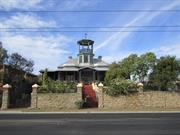
24 Preston Point Rd East Fremantle
East Fremantle
Metropolitan
Constructed from 1899 to 1902
| Type | Status | Date | Documents |
|---|---|---|---|
| Heritage List | Adopted | 17 Nov 2015 | |
| State Register | Registered | 24 Jul 2001 | HCWebsite.Listing+ListingDocument, HCWebsite.Listing+ListingDocument |
| Type | Status | Date | Documents |
|---|---|---|---|
| (no listings) |
| Type | Status | Date | Grading/Management | |
|---|---|---|---|---|
| Category | ||||
| Municipal Inventory | Adopted | 18 Nov 1997 | Category A | |
| Register of the National Estate | Permanent | 28 Sep 1982 | ||
| Classified by the National Trust | Classified | 07 May 1979 | ||
Individual Building or Group
| Epoch | General | Specific |
|---|---|---|
| Original Use | RESIDENTIAL | Single storey residence |
| Present Use | RESIDENTIAL | Single storey residence |
| Original Use | FARMING\PASTORAL | Stable |
| Style |
|---|
| Federation Queen Anne |
| Type | General | Specific |
|---|---|---|
| Roof | METAL | Zincalume |
| Other | TIMBER | Other Timber |
| Wall | BRICK | Rendered Brick |
| Wall | STONE | Limestone |
| General | Specific |
|---|---|
| PEOPLE | Local heroes & battlers |
| DEMOGRAPHIC SETTLEMENT & MOBILITY | Depression & boom |
| DEMOGRAPHIC SETTLEMENT & MOBILITY | Immigration, emigration & refugees |
This information is provided voluntarily as a public service. The information provided is made available in good faith and is derived from sources believed to be reliable and accurate. However, the information is provided solely on the basis that readers will be responsible for making their own assessment of the matters discussed herein and are advised to verify all relevant representations, statements and information.
Constructed from 1899, Constructed from 1902
STATEMENT OF SIGNIFICANCE Knocknagow, a single storey rendered masonry construction and Zincalume custom orb roofed residence in the Federation Queen Anne bungalow style with a belvedere and associated single storey former stables, has cultural heritage significance for the following reasons: 1. The place is significant for its elevated and prominent siting, dramatic approach from the street and as a fine Federation Queen Anne style bungalow; 2. with its tall belvedere, the place has a distinctive landmark quality; 3. the place was acquired by Mary Agnes Mulcahy in 1902, and was occupied by the Mulcahy family, prominent Fremantle and East Fremantle identities, for nearly 80 years; 4. it is valued by the community as evidenced by its inclusion in heritage listings and the concerns expressed when the demolition of the stables were under consideration; and, 5. the place is rare as one of a small number of Federation Queen Anne houses with a finely detailed tall belvedere. The two houses and landscape developed on the Lot 2 to the south of Knocknagow are considered to have low significance. AESTHETIC SIGNIFICANCE No 24 Preston Point Road has exceptional aesthetic value as a Federation Queen Anne style house. Knocknagow is significant for its elevated and prominent siting and dramatic approach from the street. It retains most of the characteristic features of a dwelling of the type and period. HISTORIC SIGNIFICANCE No 24 Preston Point Road has exceptional historic value. The place has associations with the Mulachy Family. It was part of the suburban residential development associated with the expansion of East Fremantle and the subdivision of Walter Easton’s Estate from 1901. SCIENTIFIC SIGNIFICANCE N/A SOCIAL SIGNIFICANCE No 24 Preston Point Road has exceptional social value. It contributes to the community as a well known landmark on Preston Point Road and East Fremantle. It is associated with a significant area of middle class federation and Inter-War period development which contributes to community's sense of place. RARITY No 24 Preston Point Road is rare.
Federation Queen Anne Knocknagow is a single storey rendered masonry construction and Zincalume custom orb roofed residence in the Federation Queen Anne bungalow style with a belvedere and associated single storey former stables. It is rare as one of a small number of Federation Queen Anne houses with a finely detailed tall belvedere. No 24 Preston Point Road, Knocknagow, is a house constructed in rendered masonry with a hipped corrugated iron roof. Some rear sections of the place have limestone wall infill with brick quoins. The house is designed in the Federation Queen Anne style. It is uniquely designed and does not fit in with the typology precisely. It is symmetrically planned with a central door and hopper light flanked by sidelights. The facade features a full width return bull nose roofed verandah. The verandah is supported on timber posts without decorative treatments. There is a pair of bay windows distributed symmetrically about the front door. The bay windows feature French doors and double hung sash windows. The bay windows extend above the verandah to form a parapet. A gable is located centrally on the verandah and marks the entry. Above the entry at the second storey is an octagonal planned room. There is a belvedere located above this room. The room is constructed in timber framing with weatherboard cladding. The octagonal belvedere is open with a timber handrail and cast iron panel balustrade. The roof has a low pitch and terminates with a decorative finial. The roofscape is further enriched with tall stucco finished chimneys. The place retains its form and most of its details. There are additions to the rear. The place is consistent with the building pattern in the Precinct. The place plays an important role in the pattern of development of a middle class suburb.
Demographic Settlements: Residential Subdivision In September 1883 Stephen Henry Parker and James Morrison of Perth commenced subdivision of 65 acres of land to the north of Canning Road. The subdivision occurred at Swan Locations 63, 176, 219 and the south western portion of Swan Location 306. The subdivision included Preston Point Road, Alcester Gardens, Wolsely Gardens, Victoria Road, Alexandra Road, Parry Avenue, and Salvado Avenue. The Richmond Precinct was owned by Walter Easton and was named after the town of Richmond where Easton lived in England. In 1901 Easton’s sons subdivided Windsor Estate. New streets to the subdivision of the Windsor Estate were named after various members of the Easton family; Walter, Gill, Stratford and Morgan (later Osborne Road). Initially lot sizes were generous but sold at a slow rate. The initial development of the Richmond Precinct occurred at Canning Highway and Preston Point Road. Substantial residences were developed on these streets giving precedence to the future development of Richmond. The distinct architecture of Canning Highway and Preston Point Road distinguish Richmond from the surrounding area. By 1913 there were approximately 40 residences in the area between Preston Point Road and Alexandra Road. Osborne Road, Windsor Road and Gill Street had several buildings apiece by 1913. By 1931 approximately half the lots were developed. In 1921 Richmond Primary School was developed between Windsor and Osborne Road and several Inter-War residences were developed in the immediate area. In the 1930s the Workers’ Homes’ Board developed a number of weatherboard, asbestos, brick and tiled residences. Inter-War style front porches were preferred over Federation style full width verandahs. Redevelopments have occurred throughout the Richmond Precinct. Large lot sizes have allowed Richmond to be subject to the redevelopment of group and multiple housing. However, significant clusters of heritage dwellings remain throughout. No 24 Preston Point Road, Knocknagow was constructed in 1899 for Allan Murray Ayles. This follows the gold rushes in Western Australian and occurred during the latter stages of the construction of Fremantle Harbour. Knocknagow was acquired by Mary Agnes Mulcahy in 1902. It was occupied by the Mulcahy family for nearly 80 years. Mary Mulcahy’s husband, Daniel, was prominent in Fremantle and in the Irish Catholic community. Their home hosted many visiting dignitaries. Knocknagow demonstrates a high level of achievement in the Federation Queen Anne style. The place is especially distinguished by the well-executed belvedere and the fine proportions of the house.
Integrity: High Authenticity: Moderate - High
Excellent
This information is provided voluntarily as a public service. The information provided is made available in good faith and is derived from sources believed to be reliable and accurate. However, the information is provided solely on the basis that readers will be responsible for making their own assessment of the matters discussed herein and are advised to verify all relevant representations, statements and information.
A large 1890 ' s house significant for its now unique architectural character of wide surrounding verandahs in the bungalow style with lookout tower overlooking the harbour. Significant as well for its association with gold-rush hoteliers in Fremantle and the goldfields. .
A large resid ence set on high ground overlooking the harbour. The building is constructed of rendered masonry. The original CGI roof has now been replaced with mod ern profile aluminium tiling. The house has prominent chimneys and lookout tower surrounding timber verandahs with projecting portico over the formal front steps. The original high, stone street wall surmounted with wrought iron railings, wrought iron gates are still in sound condition. The roof recovering with modern aluminium sheeting affecting its original integrity.
The house was bought by Mr Daniel Mulcahy for his bride in 1895, and has remained in the family up to this day. Daniel and his brother Michael came to Australia from Tipperary Ireland sometime in the 1870's - 18801 s and founded the firm of' Mulcahy Bros , however, they soon involved themselves with gold mining and journeyed to the "Nannine" in the Murchison and from there to Coolgardie when Bailey made his discovery at Fly Flat. Ill health forced the return to Fremantle where in 1893 together with Mr John Byrne, Daniel Mulcahy became the owner of the Commercial Hotel, and later owned many hotels in Fremantle,·Perth and Boulder City.
This information is provided voluntarily as a public service. The information provided is made available in good faith and is derived from sources believed to be reliable and accurate. However, the information is provided solely on the basis that readers will be responsible for making their own assessment of the matters discussed herein and are advised to verify all relevant representations, statements and information.
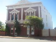
5A & 5B Riverside Rd East Fremantle
MI (2000) has as 34-36 Canning Hwy also.
East Fremantle
Metropolitan
Constructed from 1902 to 1993
| Type | Status | Date | Documents |
|---|---|---|---|
| Heritage List | Adopted | 17 Nov 2015 | |
| State Register | Registered | 16 Dec 1994 | HCWebsite.Listing+ListingDocument, HCWebsite.Listing+ListingDocument |
| Type | Status | Date | Documents |
|---|---|---|---|
| (no listings) |
| Type | Status | Date | Grading/Management | |
|---|---|---|---|---|
| Category | ||||
| Local Heritage Survey | Adopted | 17 Nov 2015 | Category A | |
| Municipal Inventory | Adopted | 15 Aug 2006 | Category A | |
| Classified by the National Trust | Classified | 19 May 1997 | ||
| Name | Type | Year From | Year To |
|---|---|---|---|
| Walter Hunter, 1993 | Architect | - | - |
| Bradley Kelsall, 1981 | Architect | - | - |
| Norman Hitchcock | Architect | - | - |
| Library Id | Title | Medium | Year Of Publication |
|---|---|---|---|
| 8807 | Glanville's buildings : 5A & 5B Riverside Road, East Fremantle. | Heritage Study {Cons'n Plan} | 2007 |
| 9497 | Glanville's Buildings, 5A & 5B Riverside Rd, East Fremantle: final report for conservation works. | Conservation works report | 2010 |
Individual Building or Group
| Epoch | General | Specific |
|---|---|---|
| Original Use | COMMERCIAL | Office or Administration Bldg |
| Present Use | RESIDENTIAL | Two storey residence |
| Style |
|---|
| Federation Free Classical |
| Type | General | Specific |
|---|---|---|
| Wall | STONE | Limestone |
| Wall | BRICK | Pointed Brick |
| Other | RENDER | Other Render |
| Roof | METAL | Corrugated Iron |
| General | Specific |
|---|---|
| OCCUPATIONS | Commercial & service industries |
| DEMOGRAPHIC SETTLEMENT & MOBILITY | Settlements |
| DEMOGRAPHIC SETTLEMENT & MOBILITY | Depression & boom |
This information is provided voluntarily as a public service. The information provided is made available in good faith and is derived from sources believed to be reliable and accurate. However, the information is provided solely on the basis that readers will be responsible for making their own assessment of the matters discussed herein and are advised to verify all relevant representations, statements and information.
Glanville's Buildings has cultural heritage significance for the following reasons: the place demonstrates the idiosyncratic architectural style of Norman Hitchcock, who practised architecture in Melbourne and later in the metropolitan area at the turn-of-the century; although altered internally, the restored exterior of the two-storey building is the best example of the full range of 'signature' details of Hitchcock; apart from being a major example of Hitchcock's residential architecture in Western Australia, the place is a key link between Hitchcock's architectural design in Melbourne and Perth; the place occupies a prime location, being particularly noticeable form the Swan River, the building is a Fremantle landmark; and, is valued by the community as a landmark building which reflects the exuberance of gold boom architecture at the tum-of-the century. Aesthetic Value Hitchcock had an idiosyncratic architectural style, which featured: pressed cement female faces to terminate corbelled party walls turned timber knobs, roman chariot wheels used as pediment brackets and stucco swags and rusticated panels, which he developed in Melbourne in the 1880s and continued to use in Perth in the 1900s. Glanville's Buildings has aesthetic significance as the principal example in metropolitan Perth of Hitchcock's decorative style. Glanville's Buildings has a landmark quality. Occupying a prime location, it impacts on vistas from the Swan river. The proximity of the house to the river, and the vistas thereto, is important in establishing and retaining the landmark quality of the house. Historic Value As a major example of Hitchcock's architecture in both Perth and Melbourne, Glanville 'sBuildings has historic significance. It is the largest known example of Hitchcock 's design in Western Australia and demonstrates the continuity of his architectural work in the 1900s. Social Value Glanville's Buildings, because of its elevated location and proximity to the river, has gained some status as a local landmark. The building contributes to the community' s sense of history and place which is reflected in the Town of East Fremantle's recognition of the building within their town planning scheme as a place of heritage value. Rarity Hitchcock designed a number of two, and even three-storey rows of terrace houses in Melbourne. However, Glanville's Buildings is the only known example of a two-storey terrace designed by Hitchcock in Western Australia. Representativeness Glanville's Buildings is a representative example of the exuberance of gold boom architecture and Hitchcock's idiosyncratic use of decorative details.
Condition. Glanville's Buildings, has been well maintained by the current owners, following internal renovations and the restoration of the building's facade. In 1994, the structure is in sound condition, although it does suffer, like a number of limestone buildings in the area, from damp in the walls. Glanville's Buildings is in sound condition. Integrity The building is currently being used entirely for residential purposes. Despite alterations of the internal spaces, Glanville's Buildings exhibits externally the characteristics of Hichcock's design and thus retains a moderate degree of integrity. Authenticity Sufficient original fabric of Glanville 's Buildings exists to permit recovery of the original internal spatial configuration at a later date, if required. In particular, Hitchcock's distinctive external decorative details are intact, or have been restored, and therefore the place retains a moderate level of authenticity.
Assessment 1997 Constructed 1902 Glanville 's Buildings was erected for Mr Herny Charles Glanville, a chemist of Market street, Fremantle, in 1902. The ground floor (street level) of the building housed tow shops: a pharmacy from which Mr. Glanville dispensed his potions, and a tailor shop operated by Rummer and Sweet. The basement and upper floors of the building were used for storage and the Glanville family's accommodation. The Glanville family owned the building until 1946. Many immigrants, attracted by the prospects of good fortune and employment associated with the goldrush, brought new ideas and raised social expectations to Western Australia in the late 1890s. This was evident in the rapid growth of the building industry and the development of architecture in Western Australia. The distinctive residential architecture style of Glanville 's Buildings is one of the more obvious example of the transfer of architectural values from the eastern states to Western Australia at the turn-of- the-century. The architect for Glanville 's Buildings was Norman Hitchcock, who came to Western Australia from Melbourne around the tum-of-the-century. In Melbourne, Hitchcock had established a reputation for his distinctive use of decorative details in speculative terrace housing in the suburbs of Carlton and Parkville. Caught up in the collapse of the Melbourne housing market and financial "crash", Hitchcock was declared insolvent in May 1891. Hitchcock was later listed in partnership with O.N. Nicholson in Melbourne, but then was not active, until he turned up practising architecture in Western Australia. Hitchcock is first listed in Wise's Postal Directory as a practicing architect in High Street, Fremantle, in 1904, but the date, 1902, on Glanville 's Buildings indicates he was in practice in Fremantle at an earlier date. Apart from being an early example of Hitchcock's design in Western Australia, Glanville 's Buildings is the largest of his known Perth buildings. Hitchcock specialised in the design of small speculative housing, particularly in the Fremantle area. Hitchcock's work is notable for his repeated use of distinctive design and decorative details that makes his architecture easy to identify. Other Hitchcock buildings in the East Fremantle area include: the 'George Street Mews', 107-121 George Street; terrace houses at 46-52 King Street; two semi-detached houses at 25-27 Sewell Street and a gable fronted detached house in Hubble Street. After 1950, there were a variety of owners of the building, and Glanville 's Buildings was subject to at least two major renovations of the interior. In 1981, Bradley Kelsall, Architects, converted the existing four flats into two strata units. In 1993, one of the two units was internally modified by architect Walter Hunter. PHYSICAL EVIDENCE Glanville’s Buildings is a three-storey building built for retail purposes with living quarters above. The building is situated on a high bank at the southern end of the property which addresses Canning Highway. The property extends down the embankment to Riverside Road, which follows the Swan River. Glanville's Buildings occupies a prime location which is noticeable from the Swan Riverhe houses of Norman Hitchcock, in Melbourne and Perth, display a distinctive array of decorative details. These include pressed cement female faces to terminate corbelled party walls, cement putti set in a gable niche, scalloped barge boards with 'tear drop', turned timber knobs, roman chariot wheels used as pediment brackets, semi-circular pressed cement chimney baffles, stucco swags and rusticated panels. Hitchcock's combinations of these decorative elements provide a theatrical effect to what are otherwise relatively modest buildings. Glanville's Buildings exhibits many of Hitchcock's 'signature' details. Spread over a two-storey facade the contrast of stucco decoration against tuckpointed brickwork is quite overwhelming, and quite unlike any other building in Perth. The building's conversion to two residential units, in 1981, changed the building's principle entrance to the rear of the building. Pedestrian and vehicular access is now from Riverside Road. Steps lead from the shared carport off Riverside Road to the ground floor. The steps separate retaining walls, that encase gardens. The building's entrance at the ground floor is approached across a paved court. Except for an awning out over the footpath and the "roman wheels" in pediment brackets, the Canning Highway facade has been restored to its original design. Render and paint was removed, brickwork tuckpointed and stucco mouldings replaced. As retail activities have given way to residential purposes the interior spaces have been subjected to a number of modifications. Some internal walls, floors, windows (on the back wall) and interior details have been modified, and it is now not easy to recognise the original spatial configuration of shops and residence within the building.
This information is provided voluntarily as a public service. The information provided is made available in good faith and is derived from sources believed to be reliable and accurate. However, the information is provided solely on the basis that readers will be responsible for making their own assessment of the matters discussed herein and are advised to verify all relevant representations, statements and information.
Constructed from 1993, Constructed from 1902
STATEMENT OF SIGNIFICANCE Glanville's Buildings has cultural heritage significance for the following reasons: • The place demonstrates the idiosyncratic architectural style of Norman Hitchcock, who practised architecture in Melbourne and later in the metropolitan area at the turn-of-the century; • Although altered internally, the restored exterior of the two storey building is the best example of the full range of 'signature' details of Hitchcock; • Apart from being a major example of Hitchcock's residential architecture in Western Australia, the place is a key link between Hitchcock's architectural design in Melbourne and Perth; • The place occupies a prime location, being particularly noticeable from the Swan River, the building is a Fremantle landmark; and • Is valued by the community as a landmark building which reflects the exuberance of gold boom architecture at the turn-of-the century. AESTHETIC SIGNIFICANCE No 5A and 5B Riverside Road has exceptional aesthetic value as a fine Federation Free Classical style commercial building. It retains most of the characteristic features of a combined shop and residence of the type and period. HISTORIC SIGNIFICANCE No 5A and 5B Riverside Road has considerable historic value for its association with the architect Norman Hitchcock. It was part of the suburban residential development associated with the expansion of East Fremantle during the Goldrush period of the 1880s and 1890s. SCIENTIFIC SIGNIFICANCE N/A SOCIAL SIGNIFICANCE No 5A and 5B Riverside Road has some social value. It is associated with a significant area of worker’s cottages which contributes to the community's sense of place. RARITY No 5A and 5B Riverside Road is not rare in the immediate context but Plympton has rarity value as a working class suburb.
Glanville's Buildings, although altered internally, is a two-storey building and is the best example of the full range of 'signature' details of architect Hitchcock. Hitchcock designed a number of two, and even three-storey rows of terrace houses in Melbourne. However, Glanville's Buildings is the only known example of a two-storey terrace designed by Hitchcock in Western Australia. No 5A and 5B Riverside Road is a brick residence with rendered details and low-pitched corrugated iron roofs that are concealed by parapets. It is a very fine and eccentric expression of the Federation Free Classical style. The street elevations is arranged to accommodate two shopfronts with their entrance doors and modest windows. A dominant feature is the highly decorative and flamboyant parapet. Glanville's Buildings exhibits many of Hitchcock's 'signature' details. Spread over a two storey facade the contrast of stucco decoration against tuck-pointed brickwork is quite striking and quite unlike any other building in Perth. As retail activities have given way to residential purposes a number of modifications. The place is consistent with the pattern of development in Plympton and plays an important role in the pattern of development of a working class suburb. The place is one of Plympton’s highlights.
Historic Theme: Occupation Plympton is a cohesive precinct, where most of the places were constructed in the late nineteenth century and the first quarter of the twentieth century. It is comprised primarily of homes for workers and their families with a high concentration of small lots with timber, brick and stone cottages. Commercial premises were established on Canning Highway and George Street. In 1981 the building was converted from a commercial premise to two residential units. As a major example of Hitchcock's architecture in both Perth and Melbourne, Glanville's Buildings has considerable historic value. It is the largest known example of Hitchcock's design in Western Australia and demonstrates the continuity of his architectural work in the 1900s.
Integrity: High Authenticity: Moderate - High
Excellent
| Name | Type | Year From | Year To |
|---|---|---|---|
| Walter Hunter, | Architect | 1993 | - |
| Bradley Kelsall | Architect | 1981 | - |
| Norman Hitchcock | Architect | 1902 | - |
This information is provided voluntarily as a public service. The information provided is made available in good faith and is derived from sources believed to be reliable and accurate. However, the information is provided solely on the basis that readers will be responsible for making their own assessment of the matters discussed herein and are advised to verify all relevant representations, statements and information.
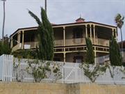
49, 51 & 53 View Tce East Fremantle
East Fremantle
Metropolitan
Constructed from 1897 to 1941
| Type | Status | Date | Documents |
|---|---|---|---|
| Heritage Agreement | YES | 28 Jan 2002 | HCWebsite.Listing+ListingDocument |
| Heritage Agreement | YES | 28 Jan 2002 | HCWebsite.Listing+ListingDocument |
| Heritage Agreement | YES | 28 Jan 2002 | |
| Heritage List | Adopted | 17 Nov 2015 | |
| State Register | Registered | 28 Aug 2001 | HCWebsite.Listing+ListingDocument, HCWebsite.Listing+ListingDocument |
| Type | Status | Date | Documents |
|---|---|---|---|
| (no listings) |
| Type | Status | Date | Grading/Management | |
|---|---|---|---|---|
| Category | ||||
| Register of the National Estate | Indicative Place | |||
| Classified by the National Trust | Classified | 03 Dec 1990 | ||
| Municipal Inventory | Adopted | 18 Nov 1997 | Category A | |
| Local Heritage Survey | Adopted | 17 Nov 2015 | Category A | |
| Library Id | Title | Medium | Year Of Publication |
|---|---|---|---|
| 5226 | Penshurst, East Fremantle : conservation plan. | Heritage Study {Cons'n Plan} | 2001 |
| 8561 | Heritage works : conservation case studies. | Report | 2007 |
| 7002 | Schematic design proposal, proposed residence, No. 49, Lot 302 View Terrace, East Fremantle, Western Australia. | Report | 2003 |
Individual Building or Group
| Epoch | General | Specific |
|---|---|---|
| Present Use | RESIDENTIAL | Two storey residence |
| Original Use | RESIDENTIAL | Two storey residence |
| Style |
|---|
| Victorian Italianate |
| Type | General | Specific |
|---|---|---|
| Roof | METAL | Corrugated Iron |
| Wall | BRICK | Common Brick |
| Wall | STONE | Limestone |
| General | Specific |
|---|---|
| DEMOGRAPHIC SETTLEMENT & MOBILITY | Land allocation & subdivision |
| OCCUPATIONS | Commercial & service industries |
| TRANSPORT & COMMUNICATIONS | River & sea transport |
This information is provided voluntarily as a public service. The information provided is made available in good faith and is derived from sources believed to be reliable and accurate. However, the information is provided solely on the basis that readers will be responsible for making their own assessment of the matters discussed herein and are advised to verify all relevant representations, statements and information.
Constructed from 1897, Constructed from 1940
STATEMENT OF SIGNIFICANCE Penshurst, a two storey late Victorian residence constructed of limestone masonry with extensive verandahs on the north-east corner and timber skillions at the rear, as well as two palm trees in front of the house on a large open site. It has cultural heritage significance for the following reasons: - The house on its corner site is a landmark, being prominently sited on Richmond Hill and visible from various vantage points around East Fremantle and along the Swan River; - The house has a particularly striking design with two multi-faceted bays at right angles to one another on the north-east corner, around which is wrapped a two storey verandah; - The place has historic value for its relationship with shipping in Fremantle, particularly its connection with the firm of Symon, Hammond and Hubble; - As a landmark and historic structure, Penshurst contributes to the local community's sense of place; and, - The place is also associated with a number of prominent personalities and families who have at different times owned it, including the Hammond family, Phillip Collier M.L.A. and Oliver Strang. Additions to the south of the house constructed of brick, concrete and asbestos, are intrusive to the character of the place. Infill to the upper storey verandah comprising asbestos sheet cladding and louvered windows is also deemed to be intrusive to the character of the place. The houses to either side of the place have no significance. AESTHETIC SIGNIFICANCE Penshurst has exception aesthetic value as a two storey late Victorian residence and for its landmark qualities. The place is prominently sited on Richmond Hill and visible from various vantage points along the Swan River including Cypress Hill in North Fremantle and Monument Hill in Mosman Park. Penshurst's architectural form is particularly striking. HISTORIC SIGNIFICANCE Penshurst has exceptional historic value for its relationship with shipping in Fremantle and particularly its connection with the firm of Symon, Hammond and Hubble. A number of prominent personalities and families have at different times owned Penshurst, including the Hammond family, Phillip Collier M.L.A. and Oliver Strang. The Hammond family has shown an ongoing interest in the place. The significance to the family is in part attributed to the name of the place which is a link to the family's origins in England. SCIENTIFIC SIGNIFICANCE N/A SOCIAL SIGNIFICANCE Penshurst has considerable social value for its visual prominence and heritage character. Penshurst is a well-known landmark in East Fremantle and contributes to the community's sense of place. The local importance of the place as a landmark is further demonstrated by the recent renaming of a section of Gordon Street to Penshurst Street. RARITY Penshurst is a late Victorian residence of an unconventional design. The plan arrangement is unusual. The north-eastern corner is flanked by two multi-faceted bays at right angles to one another and hemmed by a two storey verandah. There was in all probability no other building built to this plan configuration
Federation Penshurst is a two storey late Victorian residence constructed of limestone masonry with extensive verandahs on the north-east corner and timber skillions at the rear, as well as two palm trees in front of the house on a large open site. It has a particularly striking design with two multi-faceted bays at right angles to one another on the north-east corner, around which is wrapped a two storey verandah. No 51 View Terrace, Penshurst, is a substantial late Victorian dwelling. The place exhibits the exuberance of WA’s Gold Boom era. It is a two storey house constructed in limestone and brick with a hipped corrugated iron roof. It is asymmetrically composed with two multi-faceted bays at right angles to one another on the north-east corner. The internal planning of the building is also unusual because of the arrangement of these bays. A two storey hip roofed verandah wraps around the residence. The verandah is supported on timber posts with post brackets. A simple frieze spans between posts on the ground floor. A vertical timber balustrade spans between the posts on the first floor. Pairs of doors and hopper lights are located both floors on the north east corner. The doors are flanked by double hung sash windows. The walls are limestone with brick quoins. The roofscape features stout brick chimneys. Penshurst has significant landmark qualities. It is prominently sited on Richmond Hill and visible from various vantage points along the Swan River including Cypress Hill in North Fremantle and Monument Hill in Mosman Park. The place retains its form and most of its details. There are additions and a garage to the rear. Access to garage is via Penshurst Street. The place originally was set on a substantial lot. It has since been subdivided into three lots with residences built either side of the place. The place plays an important role in the pattern of development of a middle class suburb.
Historic Theme: Demographic Settlement The Richmond Hill Precinct was originally Location 333-336 Swan District which was acquired by John Clayton in 1861-64. As subdivisions occurred throughout East Fremantle new land names were taken from original names and adapted. The Richmond Hill Precinct was once a part of the Richmond Precinct. The Richmond name originated from the town of Richmond in England. Walter Easton, the owner of the Richmond Precinct, had lived in Richmond prior to arriving in Western Australia. In 1891 the precinct was sold to David Symon and David William Harwood. Symon was an ironmonger, shipping merchant, a senior partner in a firm of merchants and a member of the Legislative Assembly for South Fremantle. Harwood was a prominent businessman, the founder of Harwood Brewery and was known as an avid horse racer. Subdivided lots to the precinct began to sell between 1897 and 1898 following the completion of land surveys. Due to the requirement for the provision of costly services such as water and electricity to the subdivided lots, Symon and Harwood decided to sell the estate in its entirety. The ‘Brighton Estate’ is identified on a 1903 property map as the area between Preston Point Road and David Street (now Petra Street) including View Terrace and Pier Street. A water tank was located on a site between Pier Street and View Terrace (Lot 43) which was largely chosen for its elevated position. The tank, however, was later replaced in 1977 by a multi-storey water tower which is still present today. Development in the estate progressed very slowly and by 1945 there were only 10 residences in Pier Street. A small adjoining portion of land from View Terrace to Fraser Street and west of Petra Street was developed in 1919. The development was around the site of the old Bicton Racecourse and was named the ‘Riverside Bicton Estate’. Subdivision of the remaining land in East Fremantle was complete by the 1930s. By this time the land had been significantly developed. During this period developments commenced in Petra Street and a group of Inter-War California Bungalows were built between View Terrace and Preston Point Road. This development period presents a collection of buildings which were constructed within a similar time frame while demonstrating a variety of styles. Developments were of timber and masonry construction with face brick finishes, weatherboard and asbestos cladding. A shortage of building materials following the Depression and WWII led to a more simplified building style and the emergence of the Post-War austerity houses in Richmond Hill. A later era of development in Richmond Hill occurred around Locke Crescent between the 1950’s and 1960’s. Many new developments have occurred in the Richmond Hill Precinct in the last 30 years.
Integrity: High Authenticity: Moderate - High
Excellent
This information is provided voluntarily as a public service. The information provided is made available in good faith and is derived from sources believed to be reliable and accurate. However, the information is provided solely on the basis that readers will be responsible for making their own assessment of the matters discussed herein and are advised to verify all relevant representations, statements and information.